| The origins of the town are now very obscure due to
intense coal mining during the 18th and 19th centuries
that destroyed any archaeological evidence of
Darlaston's past. There were no Roman Roads in the
immediate proximity and so there is nothing to suggest
that there was any occupation at that time. The nearest
roads were Watling Street in the north and one from Wall
to the fort at Metchley that went through Sutton
Coldfield. Most of South Staffordshire and the West
Midlands was originally covered by forest, scrub and
marsh. Early colonisation started in the 6th century
when Anglo-Saxons came from France, The Netherlands,
Germany and Denmark.
Angles and Saxons first reached our shores during the
Roman occupation and were mentioned by the Roman
historian Ammianus Marcellinus who considered them as
barbarians along with the Picts and Scots. He mentions
raids in 365, and the mid-fifth century Gallic Chronicle
records a large raid in 410 after the Roman army had
departed.
At this time there were frequent raids by continental
pirates and many towns employed mercenary soldiers for
protection. These soldiers were Angles and Saxons from
northern Germany who brought their families with them
and were given farmland as payment for their services.
Soon the mercenaries realised that they were stronger
than their employers and so began to take over the
running of many areas. The Anglo-Saxons slowly colonised
England, moving northwards and westwards, pushing the
native Celts into Cornwall, Wales and Scotland. By 850
A.D. there were three competing kingdoms; Mercia,
Northumbria and Wessex.
South Staffordshire was a part of Mercia, which was
derived from the old English word “Mierce”, meaning
People of the Boundaries. The kingdom developed from
settlements in the upper Trent valley and was colonised
by a band of Angles called the Iclingas. Slowly the area
was populated and the kingdoms of the Saxon and Angles
in the midlands amalgamated to form the kingdom of
Mercia.
Settlers moving into the area would have found or made
clearings in the woodland to build their houses, keep
their cattle and grow their crops. Evidence for such
clearings and settlements can be found in many of the
names of local towns. The old English word “leah” means
a woodland clearing and can be found in some local place
names:
Bentley, Brierley Hill, Coseley,
Cradley Heath, Dudley, Sedgley and of course the area in
Darlaston known as The Leys.
The old English word “halh” meaning a pocket of land
appears in Willenhall and the word “tun” meaning a
settlement is found in Bilston, Wolverhampton and
Darlaston itself.
|
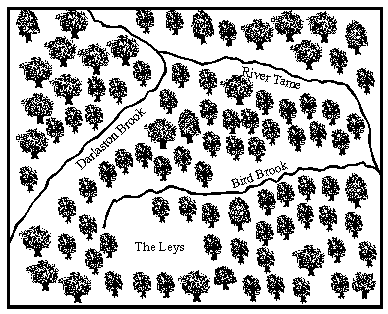
Darlaston before
colonisation. |
The map shows how Darlaston may have been in the 7th
and 8th centuries when people first settled here.
Darlaston Brook follows the Walsall branch of the
Birmingham Canal Navigation, and joins the River Tame in
Shepwell Green. It marked the historic boundary between
Willenhall and Darlaston, but unfortunately most of it
was culverted when the Black Country Route was built in
early 1995
Bird Brook began just north of Stafford Road, and
approximately followed Rough Hay Road, from where it
went across The Green. It then followed Richards Street
and The Flatts to join the River Tame near James Bridge.
It was culverted late on in the last century and so has
nearly been forgotten.
Stafford Road joins The Leys, and until the end of the
19th century it was called Baulk Lane. In medieval times
and earlier, agriculture was carried out using the Open
Field System. The available land was divided into three
large areas, which in turn were divided into small
strips. These were allocated in such a way that each
person had an equal share of the most fertile, and least
fertile land. As there were no fences, each person's
land was separated from his neighbour's by unploughed
strips, which were also used for access. These were
called baulks, and often survived to become modern
roads, as did Baulk Lane.
In about the 8th century a tribe called the Anglian
Mercens came from the north. Initially they followed the
Trent Valley, and began spreading along the valleys of
the Tame and its tributaries. They were known as the
Tomsaetan (dwellers by the Tame), and would have been
the first people to settle here. There were several
natural advantages for them in this area, the ready-made
clearings, a good water supply from the local brooks,
and a slightly elevated position making the site easily
defendable. Darlaston possibly comes from the name
Deorlaf's Tun or town, which could have been the name of
the leader of the first tribe to settle here. It was
originally called Deorlaveston.
| Read about the
Anglo-Saxons |
 |
Darlaston was not mentioned in the Doomsday Book, but
this doesn't mean that it did not exist in 1086, as many
other local villages such as Walsall were also excluded. Bentley was
included in the Manor of Willenhall, and Darlaston could have
been considered to be part of the Manor of Wednesbury,
or more likely the Manor of Sedgley, which in those days
covered a large area. From the middle ages and possibly
earlier, Darlaston was part of the Manor of Sedgley. As
recently as 1882 a part of Sedgley Parish known as
Barnes Meadow became part of Darlaston. This is
the area of George Rose Park that is adjacent to the
canal.
It became part of Darlaston under the terms of the
Divided Parishes Act of 1876. In 1935 it became the King
George V Playing Fields to commemorate the King's Silver
Jubilee. It is now part of Grace Academy. From the 12th to the 15th centuries Darlaston was
ruled by the de Darlaston family who were the lords of
the Manor. The existence of their manor house was long
forgotten until a reference was discovered in a document
which recorded that Edward Hayes, Lord Stafford's
steward, lived at Darlaston manor house in 1543. The
Hayes family lived there after the de Darlastons had
died out, the house was then called the Great Croft. It
is impossible to determine the exact location of the
manor house, but there are several clues which all point
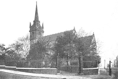
to a possible site. It was customary to build a parish
church close to the eastern side of the manor house with
a straight path leading to it. Once a lord of the
manor's funeral procession had passed this way, it would
remain in use as a public right of way, often still
existing today. |