|
Darlaston and many of the
neighbouring Black County towns started life as a small
hamlet, on top of a hill. It seems that our Anglo Saxon
ancestors preferred the high ground, presumably because
it was easily defendable, and had suitable land for
their cattle and crops.
Since those early times, bread has
been an important part of the diet, and flour was a
necessity. The earliest powered flour mills in the
country were watermills. There was one in the James
Bridge area of Darlaston, close to Bentley Mill Way,
which is named after it. In 1239 Thomas de Darlaston
granted William de Bentley the right to establish a mill
and mill pond, and divert all of the local waters for
the purpose.
Windmills started to be built in
England in the later part of the 12th century. Darlaston
was an ideal location for a windmill, particularly above
the western slope of the hill, facing into the
prevailing wind. There were two windmills in the area,
the largest being Darlaston Mill, which stood on the
brow of the hill near to where Dorsett Road is today.
The large tower mill is marked on Morden's map of 1695,
and one hundred years later was advertised in the
'Staffordshire Advertiser' by Mr. J. Gough as 'a capital
brick-built windmill'.
It was purchased by George Smith
who ran the mill for around 40 years. He owned a large
area of land behind the mill, and erected a street
there, which he called Smith Street. He sold building
plots on either side, and the street soon filled with
houses. It ran westwards from The Leys (opposite the end
of New Street) to School Street and Old Church C.E.
Primary School. The street and houses were demolished in
the early 1970s when the 15 storey blocks of flats were
built on the Leys.
The mill is listed in Pigot &
Company's 1842 Staffordshire Directory. The miller was
Samuel Smith, possibly George's son. Within a few years
it was acquired by John Silvester, and continued in use
until about 1860. On the 1886 Ordnance Survey map it is
marked as disused, but does not appear on later
editions.
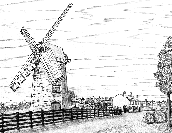
Darlaston Mill by Bev
Parker. A view of the windmill as it may
have looked in the mid 1830s. The dirt track
on the left is now Dorsett Road, and the
dirt track in the right foreground is now
Dorsett Road Terrace. To the right of the
windmill is Mill House, with Cock Street in
the background. The houses behind the
windmill were in Smith Street. |
The mill stood next to a dirt track
that ran from Cock Street to Wolverhampton Street across
an open area of land called 'Bonfire Piece'. The land
was owned by the Dorsett family, and when developed
became the area of housing around Dorsett Road and
Charles Foster Street. When the mill was in operation
there were coal mines near to where Charles Foster
Street is today, which were owned by Joseph Davis.
Dorsett Road Terrace was a dirt track leading to Mill
Lane, Globe nut and bolt works, and Mill Colliery.
Mill House stood near to the
windmill, and is still there today, roughly opposite the
junction of Dorsett Road and Dorsett Road Terrace. It is
likely that the Smith family lived there. A later
occupant was Simeon Partridge and his family. He was a
grocer with a shop at 28 Pinfold Street, who began to
make tallow candles. He opened a small candle factory on
the corner of Walsall Road and Crescent Road, which
burned down in 1900. The business later moved to Heath
Road.
|
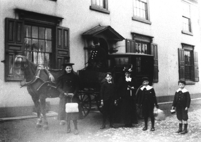
The Partridge family
outside Mill House. From the collection of
the late Howard Madeley.
|
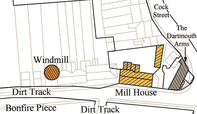
The location of the
windmill can be seen from the map above. The
windmill, Mill House, and the Dartmouth Arms
pub are superimposed on top of a modern map
which shows today s houses, gardens, and
Dorsett Road.
|
|
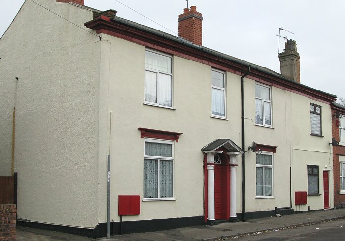
Mill House, as it is
today. |
Darlaston's second windmill stood
near the junction of Mill Street and Birmingham Street
and was known as King's Hill Windmill. Unlike Darlaston
Windmill it was a post mill, made of wood, mounted on a
central pole. The whole building would have been turned
into the wind so that the sails could rotate. It is
listed in Plot's 'History of Staffordshire' published in
1682, and seems to have remained in use until the end of
the 18th century. |
