|
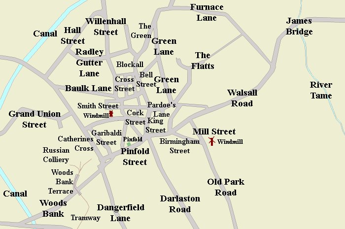
Baulk Lane |
Is the old name of Stafford Road. The name was
changed in about 1920. Baulks were unfenced areas of
agricultural land that were divided into strips with
footpaths alongside. This suggests that the land
around Stafford Road was farmed in this way. |
|
Bughole |
Was the name of part of The Crescent on the
boundary between Darlaston and Willenhall. The name
is derived from the medieval 'buggehol' meaning
a hollow haunted by an evil spirit. When the Grand
Junction Railway was built in 1837, the level of the
road was raised for the bridge to be built over the
railway. The road then ceased to be in a hollow and
became part of The Crescent. |
|
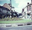
Bull Stake |
Since the Middle Ages, The Bull Stake has been a
prominent part of the town centre, obviously named
after an area once used for bull baiting. Now that
the traffic island has gone, it is has lost its
prominence and is just a
busy road junction between Pinfold Street, Walsall
Road, Darlaston Road, and King Street. Although it has lost
its significance, the name is still widely
used. |
|
Catherines Cross |
The name dates from the 1830s. It is used on
Joseph Welch's map from 1838, but on his survey for
the Tithe Map in 1837 it is named as Catton's Cross.
Catton could have been a local landowner, so maybe
the name Catherine is derived from this. In the 18th
century it was known as Mr. Offley's Waste, named
after the Lord of the Manor and landowner. |
|
Cock Street |
This is the old name for High Street which was
used until the end of the First World War. It is
still called Cock Street on the 1918 Ordnance Survey
map. The street disappeared in 2002 when the area
was redeveloped for the ASDA store. |
|
Furnace Lane |
The lane was named after the ironworks that were
once prominent at Darlaston Green. By 1799 a small
stone-built blast furnace was working there and in
1826 Darlaston ironworks, in the form of Bills and
Mills opened at Lower Green. On the 1884 Ordnance
Survey map it is called Heath Road, the name we
still use today. |
|
Garibaldi Street |
The street was named after the Italian
nationalist, Giuseppe Garibaldi. The northern part
of the street was called Mill Street. In 1910 the
whole street became Mill Street, which was named
after Darlaston windmill that stood at the top of
the hill, beside where Dorsett Road is today. |
|
Great Union Street |
Is the old name for Forge Road. The street was
named after the 1800 Act of Union between Britain
and Ireland, which came into force in 1801. By 1838
the street name had been changed to Forge Road,
named after Herberts Park Forge. |
|
Great Croft Street |
Was on the northern side of Pinfold Street,
where St Lawrence Way is today. It was between
Pinfold Street and several other streets, which have
long disappeared. They were Campbell Pace, Blakemore Lane, and
High Street. Great Croft Street was named after Darlaston's
12th century manor house that stood
nearby. |
|
Green Lane |
Is the name of a long-gone road that ran from
where Slater Street is today, to the junction of
Bell Street and Bush Street and to the northern end
of Bush Street. The section at the junction with
Bell Street was known locally as 'Sewerage Street'
because that is where the early open sewers were
emptied. |
|
James Bridge |
The area has been known as James Bridge for many centuries. It is named after the bridge
that carries the Walsall Road over the River Tame. |
|
Meeting Street |
Bilston Street was the centre of early Wesleyan
Methodism in the town, where the first preaching
house stood. After its opening, in Easter 1762, the
road became known as Meeting Street, a name that was
used until the 19th century. The site of the meeting
house is roughly at the junction of St Lawrence Way
and Bilston Street. |
Mill Street,
King's Hill |
Mill Street is named after King's
Hill windmill that stood at the junction of Mill
Street and Birmingham Street. It was a wooden post
mill, mounted on a central pole, so that it could be
turned round to face the wind. It existed in the
17th century and survived until the middle of the
19th century. |
|
Pardoe's Lane |
Is the old name for Victoria Road. It has
existed since the Middle Ages and is believed to be
named after the old English word 'parlur' meaning a
small piece of enclosed land. It became Victoria
Road in 1887 to commemorate Queen Victoria's Golden
Jubilee. |
|
Pinfold Street |
This is an ancient street that is named after
the pinfold, where an official, called the pinder,
impounded stray animals until their owners had paid
a fine to collect them. It is marked on the map
above in green and is supposed to have been roughly
on the site where Cownley's hairdressers now stands. |
|
Radley Gutter Lane |
This was named after Radley Gutter, a brook,
possibly part of the medieval Hindbrock (Back
Brook), a tributary of the River Tame that supplied
water to the local fields. In the 19th century the
area was heavily mined and covered in spoil heaps
which resulted in the disappearance of the brook.
The lane later became known as Rough Hays Lane until
the area was redeveloped in the 1920s when the
council housing estate appeared. It then became
Rough Hay Road. |
|
Railway Street |
The street was built in the late 1880s and
officially named after the London & North Western Railway's Darlaston Branch
Line, in June 1890. It was built as an upper class
residential road, but the residents were not happy
living next to the railway. Trees were planted to
hide the railway and by 1901 the street had been
renamed Avenue Road. |
|
Rough Hay |
The name is extremely old and refers to a
medieval name for a clearing in a wood or an area of
scrub, possibly used for grazing cattle. |
|
Smith Street |
George Smith was one of the last millers at
Darlaston Windmill. He owned some land to the north
of the mill, that he sold for housing development.
He created the street along which the houses were
built and named it Smith Street after himself. |
|
The Flatts |
This was the site of one of Darlaston's medieval
fields. A flatt was a strip of cultivated
agricultural land, after which the road was named.
The modern road appeared in the 1930s when the
houses were built. It had previously been known as
The Golden Flatts and ran from the end of the
present road to Heath Road and its junction with
Kendricks Road. |
|
Woods Bank |
This was the old name for the road from
Catherines Cross to Moxley that is now called Moxley
Road. It was named after the Wood family who owned
much of the land in the area and also Moxley Brick
Works. The name has since been used for the Woods
Bank Housing Estate that was built along the eastern
side of Mill Street. |
|
Woods Bank Terrace |
This is the site of an old tramway that ran from
the Russian Colliery to Moxley ironworks, both owned
by the Rose family. The Russian Colliery was on the
site of the old Wake Field which is now Pinfold
Street Primary School playing fields. |