|
|
|
|
|
Molineux Alley had got its name by 1890 and may have had it earlier than that. But that cannot always have been its name, as it pre-dates the first appearance of Mr. Molineux on Isaac Taylor’s map of 1750. What is was called before that is not known; but we use the name in this article for its whole length, from what is now the Molineux Hotel to where Dunstall Park now is.
Wolverhampton grew up on top of its hill and gradually spread along the hill top. Major roads lead out in the direction of the nearby larger towns. In the area in which Molineux Alley lies the major roads, which may be taken to be very old roads, were the road to Shrewsbury, known now at Tettenhall Road; and Stafford Road. Between those major roads one would expect to find lesser roads whose function was to give access to the agricultural land in that area. It seems that there were three such roads. One was what is now New Hampton Road, which Anthony Rose, in his book “Whitmore Reans”, refers to as having been a cart track before urban development took place in the area – when it was known as Whitmore End Lane. It would have skirted the boggy land on which West Park now stands and given access to much of the agricultural land almost all the way down to the Tettenhall Road near the Smestow at Newbridge. On the Stafford Road side it is likely that the line of road now indicated by Molineux Way, Staveley Road, Dunstall Road and Dunstall Lane had its origins as this sort of agricultural access road. Between these two lay the road which is now represented by Molineux Alley. (There was a general tendency for both major and minor roads to radiate from a town centre; and for the roads mainly used for agricultural purposes to be so arranged, in their number and courses, as to give access to every field. This layout can be seen very clearly in the case of the land to the north east of Bilston town centre. It is not quite so apparent here but clear enough to show the principle at work).
Molineux Alley started near the town centre, in North Street. Like other roads from the town centre it did not go straight down the hill but slanted across it to give an easier slope down the hill. This section of the road is now the pathway which runs from Molineux Hotel, past the Molineux stadium to Waterloo Road. From there on it continues in a direct line across the flatter ground where the fields would have started.
The Alley does not seem to have lead to any settlement of any size but its ultimate destination may have been Dunstall Farm. That also seems to have been the destination of Dunstall Road. On the other hand that Farm may postdate the road which did not run directly to it, and seems to have continued as far as the Tettenhall to Aldersley Road on the far side of the Smestow. But a way such as this does not have to have had an end point other than a field. This sort of way ran amongst the fields for the purpose of giving access to the fields. It will be remembered that those who farmed the fields would, in the early days of the town and up to the time the fields were enclosed, have lived in Wolverhampton and would have sought a market in Wolverhampton. In later times, say from about 1700 onwards, when agricultural land came into more unified ownership, the fields through which the Alley ran may have been farmed from Dunstall Hall or from Whitmore End Farm.
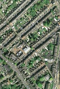
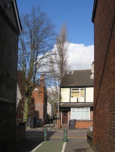
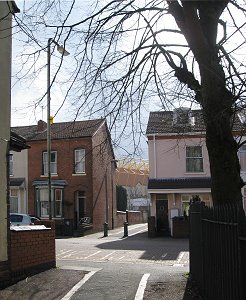
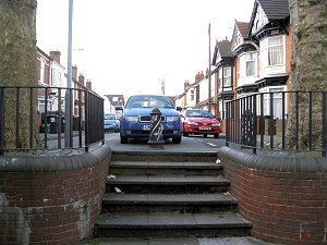
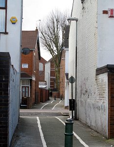
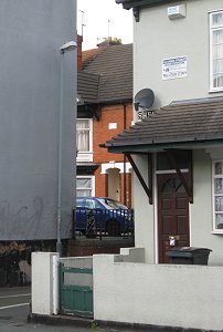
This is not known to have happened in the case of the Alley and it is the case that there is a right to go along it with motor vehicles, horses and bikes as well as on foot. Anything which prevents this is an illegal obstruction. Roads tend to persist in the landscape, more so even than field boundaries. The old maps show that when development took place around the road it had to respect the line of the road. The basic law is neither houses nor anything else can be built over highways. We see this principle in operation at points where the Alley crosses the line of roads. In these cases there are either gaps in the terraces which allow the Alley to pass through; or roads lead up to the Alley and then stop. (This feature is particularly noticeable in aerial views). The tendency for an old road to affect development in this way is reinforced by the fact that roads also define field boundaries. When land is bought and sold it is usually sold by the field. When developers bought land for housing they usually bought a whole field, with access to a road, and developed it as best as the field shape allowed. This is probably why some roads stop at the Alley and do not run across it.
So the new lines of the Alley were and are certainly highways. What is not so clear is whether the old lines remain highways! So Great Hampton Street, which was to be the central spine of the New Hampton development, disregards the Alley – but the rest of the development does not.
And so the alley continues on its old route, in places across fields. Isaac Taylor’s map of 1750 seems to show the alley running past Molineux House and Mr. Molineux’s Close; but it is not clear. It does not show any direct route from the town centre. Anyone standing on High Green and wanting to get to this road would have had to go past St. Peter’s to Horsefair, following that zig-zag road to Goat or Tup Street (later North Street) and then following that road to the turn off to Molineux Alley at Wadhams Hill.
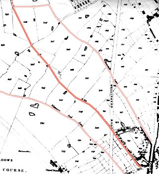
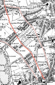
The next relevant map we have is the Tithe Map of 1842. This shows the Alley quite clearly. From North Street one would have turned down Wadham’s Hill and then into Molineux Alley where it ran along the wall to the south side of Molineux House (now the Molineux Hotel) and its grounds to where it crosses the then new Wellington Road (now Waterloo Road) to reach the fields. It forms the boundary between two fields and is shown as a fenced road. But from there on it is shown as fenced only on the northern side as it runs between five more fields. It then runs diagonally across three more fields. A possible explanation for all this is that when the area was enclosed by agreement, it was easy enough to create fields of a suitable standard size on each side of the Alley and between Whitmore End Lane southwards and Dunstall Lane northwards. But, as these two roads diverged, two fields of the standard size were not enough to fit, so the attempt to use the Alley as a boundary was abandoned and the owners had to accept fields of a suitable size and shape but with a highway across them. In the resulting pattern of fields there seems to be only one field which is dependant on the Alley as its only access. In fact the Alley was not, at this point in time, a necessity for agricultural access but, being a public highway, it continued in existence. One suspects that, had the enclosure taken place under statute, the Alley would have been closed.
The route then wanders somewhat between fields, skirts the grounds of Dunstall Hall with a couple of right angled turns, then crosses the Smestow to join the Tettenhall to Autherley Road. It is quite possible that the Alley originally took a more direct route; and that when Duntall Hall was created the Alley was divrted, whether legally or not, around its grounds. OS maps from the earlier part of the 19th century present dating problems and are difficult to interpret but they suggest that the Dunstall Road and Lane route was the more important one and Molineux Alley played only a subsidiary role.
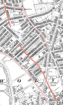
But after that fields remain on both sides, though nearer Great Hampton Street one of them seems to have been split into allotments of some sort – possibly for market gardening – and a start has been made on Paget Street which also stops dead at the Alley. And then there is Great Hampton Street. Where the Alley joins it on the south-eastern side the houses stop, the Alley runs through and, bounding it on the south-eastern side, is what appears to be a factory. But on the other, north-western side of the road, the last house is built across the line of the Alley and the Alley can been seen continuing around the north-eastern side of that house. Technically this was an obstruction of the highway. What procedures, if any, were used, to permit this to happen is, of course, unknown. From there the Alley crosses more fields until it reaches it junction with Dunstall Lane, where houses have been built on that road and on Chester Street, in a way which respects the line of the Alley.
There were, in 1901, still some houses to be built but simply as infilling in the established street pattern. The whole area through which Molineux Alley runs had been developed mainly between about 1880 and 1900. The houses are typical of their period (and are, in many ways, similar to those which were being built at much the same time on what had been the Graiseley Estate between Lea Road and Great Brickkiln Street).
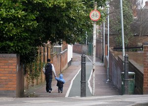
Are there any implications in all this for the proposed restoration of Molineux Alley? It is clear that the Alley, in additional to its current usefulness, is of historic interest. It is reminder of the older agricultural background of the city. Its course has acted to regulate how the present streets and houses were laid out. These developments have given the Alley its present character of an enclosed space with almost no houses or other buildings fronting it but with irregular breaches in the enclosure which have great landscape value. The factors certainly indicate that the Alley is worth preserving – and if it is worth preserving it is worth upgrading and maintaining. They also perhaps indicate that Victorian style bollards, lamp posts and any other street furniture, are worth preserving as being in keeping with the date of the area’s development. The history may also suggest that features might be created in and around the Alley which in some way hark back to the agricultural past and to the Alley’s role as a link between the market town and its fields.
|