| Introduction
In the 13th century Wolverhampton became a prosperous market
town catering for the surrounding area. A market has been in
existence in the town since before 1204 when the market day was
moved from Sunday to Wednesday. In 1258 King Henry III granted
the town the right to hold the weekly market on every Wednesday.
Good roads would have been an essential requirement for the
development of the market town and Wolverhampton must have
developed many links with the Welsh border country to the west,
which was home to some of the best sheep in the country. Over
the next century Wolverhampton's fortunes continued to improve
and the town became wealthy from the wool trade. Wool was
purchased by the local wool merchants and sold on to Europe
where it was used by clothing manufacturers.
|
 |
Read about the local wool
trade |
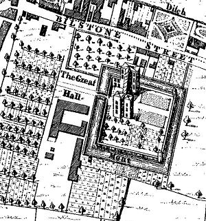
The Great Hall as shown on Taylor's map of
1750. |
Wolverhampton had a number of successful wool
merchants, the most prominent and influential of which was the
Leveson family (pronounced Leweson). In the late 16th or early
17th century the family built a grand moated mansion house,
complete with gardens and an orchard. The house was originally
called 'The Great Hall' and later became known as 'The Old
Hall'.
A recent excavation at the Old Hall Street Adult Education
Centre has uncovered some of what remains of the north western
corner of the hall and moat. The excavation was carried out by
Birmingham University's Field Archaeology Unit and a lot of
interesting discoveries were made. This important excavation has
given us a unique opportunity to investigate Wolverhampton's
medieval past. The following description has kindly been written
for us by Mike Shaw, Black Country Archaeologist. |
| A drawing showing the Old
Hall and moat. From a 1907 edition of the Wolverhampton Journal. |
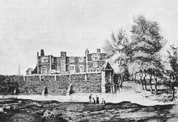 |
| Archaeological
excavations at the Old Hall, Wolverhampton
Excavations in Wolverhampton have uncovered the remains of
the Old Hall, one of the principal buildings of the
medieval/early post-medieval town. The Old Hall was built by the
Leveson family who were wool merchants and one of the most
prominent and influential families in Wolverhampton. It is shown
on the earliest map of Wolverhampton (Taylor's map of 1750) as a
large mansion house with gardens and orchards, surrounded by a
moat.
The work was carried out between October and December 2002 by
Birmingham University Field Archaeology Unit and represents the
culmination of a process of documentary research and trial
excavation designed to locate the precise position of the hall.
The present excavations located a section of the moat of the
hall which proved to be around 10m (30 feet) wide and 3m (10
feet deep). Within this were located the curtain wall around the
moat and the foundations of a wing of the hall itself. The
foundations were of stone, around 1.4m (4 feet wide) but we know
from later drawings that the hall was a three-storey brick
structure. There may, however, have been an earlier building on
the site as John Leland in his itinerary, written in the 1530s,
refers to the ancient house of the Leveson family on the edge of
Wolverhampton.
The hall remained in the hands of the Leveson family through
the 16th and 17th centuries but by the 18th century was in the
hands of Joseph Turton, a local ironmaster. Contemporary maps
show that the ditch had been filled in by 1842 but the hall
itself survived until 1883 when it was demolished. Prior to this
it was in the hands of William and Obediah Ryton who turned much
of the hall into a japanning factory. |
|

The location of the excavation site.
|
The excavations recovered a wide range of artefacts,
especially from the fill of the moat ditch. These include pottery
tablewares, glass bottles and even a silver spoon. Preliminary
analysis suggests a 16th to 18th century date for the majority of
the artefacts. Because the moat is waterlogged organic remains have
survived very well, particularly leatherwork. Soil samples from the
moat should also tell us a great deal about the local environment at
the time and the living conditions of the townspeople.
The foundations of the hall were cut into a grey soil layer which
is suggested as being a former ploughsoil. If true it would indicate
that the hall was laid out on the site of the town fields. Detailed
micromorphological analysis will be undertaken to confirm the
interpretation. |
| The work has been funded by the City of Wolverhampton
College and Wolverhampton Adult Education Service who are jointly
developing a Learning Centre on the site.
The archaeological excavations have now been completed and the finds
and records are being worked on at Birmingham University with the
intention of completing a report on the site in 2003. An open day to
view the excavations early in December attracted over 500 people and was
covered in the local press (Express and Star, Wolverhampton Ad News),
radio (Radio WM, Saga FM) and television (Midlands Today). Discussions
are currently being held with Wolverhampton Museums and Art Gallery and
it is hoped that an exhibition of the finds and results of the
excavation can be arranged for early 2003 at Bantock House Museum. Watch
this space!
Mike Shaw, Black Country Archaeologist, 20.12.02
|
 |
A map of the site, made from a
sketch taken of a poster that was on display during the open day. |
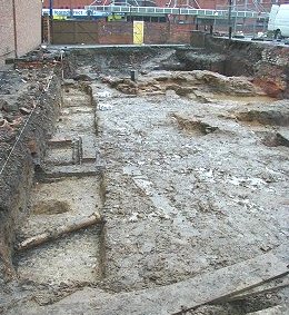
| The view of the excavation from the
south. The grey soil in the foreground is believed to be former ridge
and furrow plough soil, suggesting that the building was built on open
farmland. On the right is a mixture of foundations of 'The Great
Hall' and some 19th century buildings. The former moat can be seen at
the far end of the site. |
 |
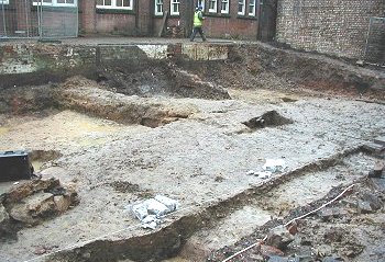 |
The south-eastern corner of the site
showing the grey ridge and furrow plough soil and some early foundations
surrounded by 19th century brick structures. |
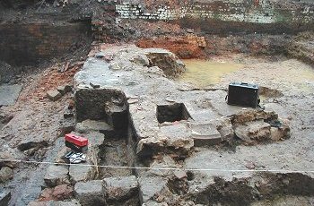
| A mixture of original, and 19th
century brickwork. The moat, which is on the far left had been filled in
by 1842 and the building was extended as part of a Japanning works. The
building originally became a japanning factory in 1767 when it was owned
by Jones and Taylor. In about 1820 it was taken over by Obadiah and
William Ryton and continued as a japanning works. In 1842 the company
became Walton & Co. |
 |
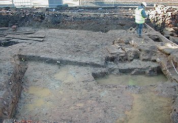 |
The same view from the eastern side
of the excavation.
The japanning factory closed in 1883,
everything was sold off and the building demolished. |
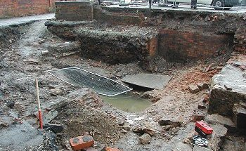
This view shows the moat excavation
from the west. The brickwork in the foreground is part of a 19th century
cellar.
A number of 16th and 17th century artefacts were recovered from this
part of the excavation. These included glass, tableware and a silver
spoon. Because the area is waterlogged organic remains are well
preserved. Items found here included leather shoes. |
 |
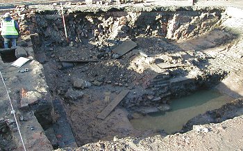 |
A view of the moat excavation from
the opposite side. This part of the excavation uncovered what are
believed to be the original foundations of the building. They consist of
massive stone foundations about 1.5m wide and are cut into the original
plough soil. The moat was not a defensive structure as in a castle but
was a status symbol, a declaration of wealth. |
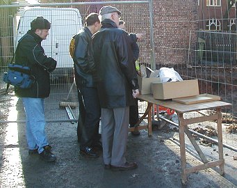
| A group of visitors inspecting some
of the finds which were on display. In total there were 35 boxes of
finds, mainly consisting of pottery and glass fragments. There was also
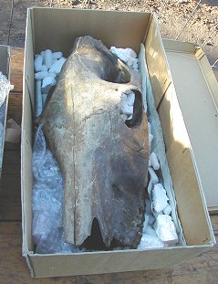
a horse's skull which was retrieved from the moat. The remaining parts
of the skeleton may still be in the unexcavated part of the site. |
 |
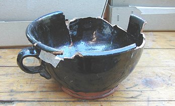 |
An example of the high quality 16th
/ 17th century pottery that was found on the site. This shows that the
building was of a high status at the time. Later pottery fragments from
the japanning days are of a much lower quality illustrating the change
of use of the building. |
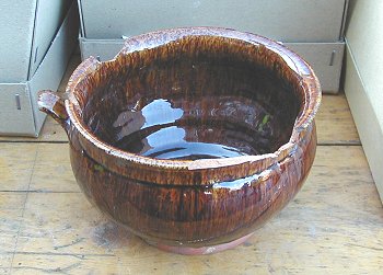
| Another fine example of the high
status 16th / 17th century pottery that was discovered here. |
 |
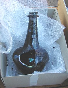 |
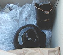
Two further examples of well- preserved high
status tableware that were found on the site. |
| The horse's skull that was removed
from the moat. |
 |
The excavation was the culmination of three years work
to locate the Old Hall. Much work remains to be carried out on the finds
which will be studied and conserved. The organic remains found in the
moat should tell us a great deal about the local medieval environment,
what plants were grown and what food was eaten by the inhabitants. When
this work has been completed it will provide a unique insight into
medieval life in Wolverhampton.
We would like to thank Mike Shaw for his help and
contribution to this article.

|
|
Return to the articles
section |
|


