|
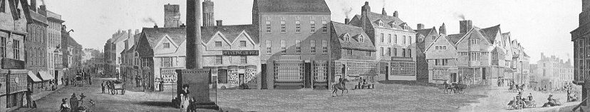
High Green in 1750.
This Market Hall, situated in the Market Place (marked A in the plan)
was an important feature in the town life of Wolverhampton. It probably was not
built before the 16th century, and (like the one at Bridgnorth) constructed of
"half-timber" supported on stone pillars, and so unlike that at Much Wenlock,
which is built on wooden pillars, or others that are constructed entirely of
stone. So much we may deduce from analogy and comparison, though our only
illustration of this edifice is that portrayed on Isaac Taylor's map of 1750, a
somewhat arbitrary drawing at best, but sufficient to show us the type of
building meant. It measured from east to west 60ft. 6in., and from north to
south 31ft. 6in., and so the room above was of a good size. Here justice was
administered and any other public business transacted.
As is well known, in 1777 an Act was passed "for Widening, Cleansing and
Lighting the several Streets, Lanes, Alleys, Ways, and other public Passages,
within the Town of Wolverhampton, in the County of Stafford, and for Taking
down, Altering or Rebuilding certain Buildings therein mentioned, and for
removing all other Nuisances and Incroachments, and for Regulating Carts and
other Carriages within the said Town." For these things could not be effected
without the "Aid and Authority of Parliament," and, as the preamble notices,
"the several Streets, Lanes, Alleys, Ways, and other public Passages within the
said Town" were "in many Places narrow and incommodious for Passengers and
Carriages," and as a "Navigable Canal" had lately (1772) been made up to the
said Town, the number of Carts and Carriages used in carrying and conveying
goods and merchandize had greatly increased and needed proper regulation.
Upwards of 125 Commissioners were therefore appointed and constituted for
putting this Act in Execution.
This meant a general clearance in the Market Place, High Green (the very name
sounds of the village), and elsewhere. The threatened buildings are mentioned in
the Act, and the Market Hall was one of them. The upper part of this building
(which is described as being a very ancient one) had been used for holding
certain Courts by the Officers of the Lord of the Manor of the Deanery of
Wolverhampton (a lessee of the Dean) and also as a Charity School (the Blue Coat
School), which then was for 50 boys and 40 girls. This seems to have been the
original schoolhouse of this foundation, the reason for which was probably due
to its attachment to the Collegiate establishment, the owner of the building.
The under part consisted of Butchers' Shops and Slaughter Houses (savoury
surroundings for a school), for which (as the Lord of the Manor, then a lunatic
contended) "certain small rents, tolls, taxes, tollages, fairs, markets, view of
frankpledge, and other rights and privileges belonging to the Manor," were or
ought to have been paid to him "by the occupiers thereof, or some of them." The
building was to be pulled down and rebuilt or removed, " in order to render the
said Market Place more convenient," and satisfaction was to be given to the
owner (or owners, as there seems some doubt as to its rightful proprietors) in
the form of some proper equivalent.
The last public exhibition in this building (we may once again note) occurred
in 1778, when John Kemble and his sister, Mrs. Siddons, gave several
performances before crowded audiences. Soon afterwards the building was removed
altogether, "being considered an unseemly edifice and a nuisance to the Market
Place," and portable shambles substituted in its place.
It would have been too much to expect such a monument to have survived during
all Wolverhampton's early industrial life; the town had just taken a step
upwards and had to appear dignified, though at the expense of what now would
have been much appreciated and worth looking at, but was then regarded as
unseemly and a nuisance!
It is not easy to make out what the excrescence on the west side of the
Market Hall in the plan was intended to represent. Possibly it was meant for a
porch or some stall, but it seems probable that it was the "certain Water
Cistern or Reservoir adjoining to the said Market House, containing from East to
West 15ft, and from North to South 17ft." Although this was condemned to be
cleared away, the same system of water works was continued on a larger scale in
1779.
From Dr. Oliver we gather two other facts of interest: that the pillory kept
in the church was, when in use, fixed in the Market Place, and that a new Market
Cross was erected by the inhabitants in 1552.
The spot marked B was another building removed by the Commissioners,
and described in the Act as "a certain ancient Building, situate in the Market
Place . . . called The Slaughter Houses and Butchers' Shambles, containing from
east to west twenty nine feet and four inches, and from north to south sixty
eight feet," and then in the several possessions of some half dozen people.
Rowlandson's sketch of the "Corn Market" (lately exhibited, and reproduced in
the "Wolverhampton Journal" of November, 1903) shows the portable shambles very
well, and the appearance of the Market Place in the early part of the 19th
century. The date given beneath the reproduction (1760) is misleading, for at
this date the Market Hall and the House (B) just described would have
appeared in the drawing; besides the artist was then only four years old and
more accustomed to do this style of drawing between 1800 and 1820.
What is on the plan marked D is meant for the pile of half-timber
shops, etc., shown in an illustration in the "Wolverhampton Journal" of
December, 1903.
At E were the two condemned "Messuages or Dwelling-houses called The
Round-about Houses, situate at the Bottom of a certain Street called the High
Green, . . . . the one whereof is now void, and the other in possession of
Elizabeth Jarvis, containing from east to west 31ft. and from north to south
51ft" The Round-about Town Well was sunk here. This curious name merely means a
place "surrounded on all sides," i.e., a building standing by itself.
C marks where what is now called Woolpack Alley passed through into
St. John's Street, but what was 100 years previously called Henny's Fold. If
connected with one Edward Henny who lived near by in 1717, the possibility of
the antiquity of the word fold in this instance (i.e., back to the
wool-stapler's days) is not very great. Title deeds show that round this passage
were a small shop, a large and small stable, and a "piece of land adjoining,
formerly used as a cock-pitt afterwards as a kid-house," and in 1778 as a
stable. In 1717, "a malthouse or malting rooms" are mentioned. These stood on
the west side of the alley, and were used as such until 1805 at least, but by
1825 were turned into three dwelling-houses. It would be interesting to know if
the other folds (such as Wheeler's Fold, Pountney's Fold or Townwell Fold) were
really survivals of former times and showed the connection Wolverhampton had
with the wool trade. But a fold need have, nothing at all to do with sheep. The
word simply means any enclosed space that could be used as a stable, and is
therefore a suitable title for these passages and yards that still exist.
To show how unsafe it is to draw any conclusions from place names in
Wolverhampton, St. John's Street is an example. The Saint portion only appears
to have been used since the middle of the 18th century but not commonly until
much later, the street being usually called John's Lane. How it got to be called
this I do not know, but in a copyhold deed of 1728 it is mentioned as "John's
Lane alias Schoolhouse Lane," evidently so named since 1715, when the
schoolhouse was built. In the 15th century the lane as such probably did not
exist at, all. Even as late as 1750 part of the street was bounded by a field,
while the gardens at the back of the houses existed till well on into the 19th
century in many cases. One must not be surprised to hear then that before Tudor
times Wolverhampton was "little better than a village."
|
 |
|
Return to the
articles menu |
|