|
The Canals Come
James Brindley's Staffordshire and Worcestershire Canal opened
in 1772. It was
part of the Grand Cross, a scheme to link the estuaries of the
Trent, Mersey, Severn and Thames by inland navigations.
The canal from the Trent to the Mersey was already under
construction when the Staffs & Worcs was started and the latter
was seen at the time as a vital part of the scheme.
The other part of this grand design is to have a cut for a
canal, of the same dimensions as the former, out of the grand
trunk from the River Trent at Haywood, at the confluence of the
river Sow with the Trent, and by Baswick, Acton, Dunston,
Penkridge, Brewood, Penford, Tunstall, Tettenhall,
Wolverhampton, Treasel,
Womborn, Holbeach, Prestwood. Stourton Castle near
Stourbridge, Kinfare, Overly, Kidderminster, and into the river
Severn, a little below Bewdley.
The
spelling of the name Pendeford is different from the original
and later version but it did appear as Penford on several maps
from the sixteenth to the eighteenth century.
|
|
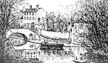
The canal at Aldersley in 1906. From an old
postcard.
|
Although it is a
contour canal, which wanders round the landscape following the easiest
route, the section through Pendeford is fairly straight, reflecting the generally flat nature of the terrain.
Indeed the canal may have helped to drain the land for
some areas along its course were wet and marshy.
|
| Penford Marshes,
Marsh Lane and Alleycroft Lake had all been mentioned in a document
relating to the beating of the bounds of
Bushbury Manor in September, 1588, the year of the Spanish Armada.
The Staffordshire and
Worcestershire Canal is running along its ten mile summit level
through Pendeford, the nearest locks being at Compton to the south
and Gailey northwards.
Opposite a warehouse to the north of Forster Bridge
is a weir which allowed excess water to drain from the
canal into the mill pond for the Old Mill already mentioned in
connection with Charles II's escape.
The weir stands next to the Pendeford Brook which passes
under the canal here and a little further south is a feeder whose
waters are drawn from the brook.
The Act of Parliament for the building of the canal,
passed in 1766, empowered the canal company to take water from
Pendeford Brook.
The marshy area on the
west of the canal is the remains of Alleycroft Lake.
Where the canal widens, a few yards north of the much rebuilt
Forster Bridge, stand
the remains of a concrete wharf, built about 1927, to deal with
waste products from the Courtaulds artificial textiles factory at
Dunstall, two miles to the south.
The boats were open, horse drawn day boats and the tiller
could be moved from one end to the other so they didn't need to be
turned. The noxious waste was carried to the tip in containers.
Remains of a gate in the fence indicated where the waste was taken
up to the tip which was in use until the 1950's.
The 1:2500 (Twenty five inches to a mile) Ordnance Survey
map of 1954 shows a crane on the wharf.
This swung the containers round onto a tramway which
divided into two, one branch running parallel to the canal for about
a hundred and fifty yards, while the other branched away from it.
The map shows a series of banks, tips and lagoons, many of which can
be identified today. A couple of buildings shown on the map were presumably
shelters for the workmen.
The traffic in waste from the factory was one of the last regular
runs on the Staffs & Worcs and it is thus interesting to note that
horse drawn boats lasted nearly till the end of trading. Known
locally as the ash banks or the chalkies, the tips demonstrate their
toxicity by the refusal of vegetation to grow over most of them.
They have long been popular with the area's motor bike scramblers
though a fence,
built at the end of 2002, has rather curtailed the sport
and the whole area is now to be developed as part of a £64 million
business park.
|
| Pendeford Rockin'
or The Narrows was known to generations of boatmen. Here, on either side of Forster Bridge, the early navvies met
an outcrop of Keuper Sandstone which was enough of a problem to their
primitive technology to force them to dig a shallow, narrow cutting. Stretching for about 600 yards, it is only about ten feet
deep but is only wide enough for one boat.
Three passing places were dug out, one by the towpath
side and two on the off side.
|
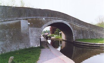
Bridge number 1 on the Shropshire Union canal. |
|
Forster Bridge (No.68) was named after the Forster family who
tenanted nearby Wobaston Manor for many generations.
It was just an accommodation bridge for a farm track
until the new road was built just before the Second World War to
ease access to Boulton Paul's new works.
The small foundations of the old bridge contrast with the
large concrete slabs of the present busy one and the rock
cutting, shaded by the bridge, gives an impression of what the
whole of the Rockin' must have looked like when first cut.
At
the end of the Rockin', Marsh Lane Bridge, number 67 from
Stourport, shows that it has been extended when the road was
widened some time in the past.
During the Second World War precautions were taken in
case of a breach being caused by an air raid.
In such an eventuality, stop planks were to be placed in
the grooves beneath the bridge.
|
|
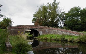
The turnover bridge. |
The canal
continues on its mainly straight course as far as Autherley
Junction, where it is joined by the Shropshire Union Canal.
This opened as the Birmingham and Liverpool Junction Canal in
1835, a few weeks after its engineer, Thomas Telford, died.
|
| The Staffs
& Worcs Company was concerned about a loss of trade to the new
concern, for the route from the Black Country up to the north
west was shorter via the new canal.
It tried to exact a heavy toll on boats using the
thousand yard section of its length between Aldersley Junction
at the bottom of Wolverhampton Locks and Autherley.
This led to a proposal, from the Birmingham Canal
Navigations and the Shropshire Union, for the Tettenhall and
Autherley Canal and Aqueduct which would have leap-frogged the
Staffs & Worcs altogether !
Not surprisingly the older company reduced its tolls.
|
| Past
Autherley Junction will be found the former sewage works basin
and then, just before Oxley Moor Bridge, is the headquarters of
Wolverhampton Canoe Club.
|
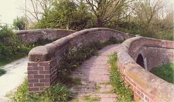
Another view of the turnover bridge. |
|
The
first mile or so of the Shropshire Union cuts through
Dovecotes/Pendeford, under a series of fine bridges.
The third one, Turnover Bridge, is so called because it
passes the towpath from one side to the other.
It is designed so that the horse could cross without
having to be unhitched from the boat.
There was a rifle range on the land to the north of the canal
between the first two bridges in the 1880's.
There might no longer have been a canal here at all if the 1846
Shropshire Union Canal and Railway Bill had been passed by
Parliament. This
was a proposal to convert the canal into a railway but such was
the opposition from the Black Country iron masters that the Bill
was thrown out.
The
present landscaped surroundings of this stretch of the
Shropshire Union contrasts strongly with the impressions of a
visitor who passed this way during the early months of the
Second World War.
As the afternoon wore on the country around us began to assume
the desolate, blackened look we had now come to know so well.
Sure enough the tall chimney stacks on the outskirts of
Wolverhampton came in sight ..... and the remaining miles to
Autherley led us into a veritable no-man's land.
The water became black with pollution, there was a
desolate swamp upon either hand and, as if this were not enough,
it began to rain steadily from a leaden sky.
The
author of this passage, L.T.C. Rolt, was one of the founders of
the Inland Waterways Association, the body which has done so
much over the past fifty years towards saving our canal
heritage.
Autherley Junction was known as Cut End to the boating families
who passed this way.
Here were stables for the horses, an office for collecting tolls
from boats passing from one canal to the other and the stop
lock.
This has a fall of about six inches and uses about 2000
gallons of water each time it is used.
The lock was insisted upon by the Staffs & Worcs. Company
so that they could control the amount of water running from
their canal into the new cut.
The
Shropshire Union was used to transport cargoes until the end of
commercial canal carrying in the late 1960's.
Oil from Ellesmere Port, chocolate crumb from Knighton to
Bournville, copper sludge from Darlaston to Manchester and
aluminium from Walsall to Liverpool being among the last
cargoes. Earlier
decades had seen coal, limestone, lime, grain, milk, flour,
hardwoods, paraffin wax, resins and animal feeds.
A
wartime entry in the Autherley toll book reads :-
6th. March 1943 'Columbia' motor boat carrying 21 tons of Flour
bound for Wolverhampton.
Toll charged - £2.0s.3d.
Wolverhampton Boat Club, which reflects the
change from commercial to leisure uses of the waterway,
has moorings between bridge 3 and Pendeford Bridge.
Formed in
1961 as Autherley Boat Club, it later moved to its present site
and has a club house on the south side of the canal where
a metal footbridge crosses by an attractive old iron wharf crane
which formerly stood at Wigan Pier!
|
|
|
|
|
|
Return to
Farm Improver |
|
Return to
the contents |
|
Proceed to
Barnhurst |
|