|
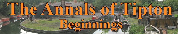 |
Tipton is a relatively flat area covering just under
3,000 acres, lying on Carboniferous coal measures, and clay
deposits. To the south and west are the Silurian limestone
and shale hills at Sedgley and Dudley, and to the south east
are the once volcanic Rowley Hills, consisting of
Carboniferous dolerite. The northern boundary is near to Lea
Brook which rises in Willingsworth and flows into the River
Tame.
The area, which was once thickly wooded, like most of the
Black Country, was crossed by Cockle Brook, which flows off
the Dudley and Sedgley hills into Wall Brook, and finally
into the River Tame. All traces of early colonisation have
disappeared due to the intense coal mining and
industrialisation during the 19th and 20th centuries that
destroyed any remaining archaeological evidence.
Although the Romans left their marks on the region, there is
no evidence of Roman roads or occupation in the immediate
area, possibly because of the thick woodland that was there
at the time. Roman coins from the first century were found
at nearby Wednesbury in 1817, including examples from the
reign of Nero, Vespasian, and Trajan. Another Roman coin was
found at Wood Green during the excavation of the railway
cutting, a piece of Roman glass came to light in Monway
Field, and a Roman brooch was recently found at Aldridge.
Other Roman coins have been found in Bilston, Perry Barr,
Great Barr, Barr Beacon, and at Stonnall near Walsall Wood.
Traces of a Roman road have been found at Bilston, and in
Sutton Coldfield where the road from Wall to the fort at
Metchley ran.
During the Roman occupation there were raids from the
continent, carried out by people from France, The
Netherlands, Germany and Denmark. They were mentioned by the
Roman historian Ammianus Marcellinus in 365 AD. He
considered them to be barbarians along with the Picts and
Scots. The mid-fifth century Gallic Chronicle records a
large raid in 410 AD after the Roman army had departed.
Around this time there were frequent raids, and so many towns
employed mercenary soldiers for protection. These soldiers
were Angles and Saxons from northern Germany who brought
their families with them and were given farmland as payment
for their services. Soon the mercenaries realised that they
were stronger than their employers and so began to take over
the running of many areas. The Anglo-Saxons slowly colonised
England, moving northwards and westwards, pushing the native
Celts into Cornwall, Wales and Scotland. By 850 AD there
were three competing kingdoms; Mercia, Northumbria and
Wessex.
South Staffordshire became part of Mercia, a name derived
from the old English word "Mierce", meaning People of the
Boundaries. The kingdom developed from settlements in the
upper Trent valley and was colonised by a band of Angles
called the Iclingas. Slowly the area was populated, and the
kingdoms of the Saxon and Angles in the midlands amalgamated
to form the kingdom of Mercia, with its capital at Tamworth.In 913 Stafford became the capital of Mercia after it had
been fortified by Queen Aethelfaed. Within a few years the
Shire of Stafford was formed, which was divided into 5
'Hundreds', each consisting of an area roughly supporting
100 households. They were Cuttlestone, Offlow, Pirehill,
Seisdon and Totmonslow.
It seems likely that early colonisation of The Black Country
began in the 7th or 8th century when a tribe called the
Anglian Mercens came from the north. Initially they followed
the Trent Valley, and began spreading along the valleys of
the Tame and its tributaries. They were known as the
Tomsaetan (dwellers by the Tame). They would have been the
first people to settle here, and no doubt made use of the
ready-made clearings, and the excellent water supply from
the local brooks. |
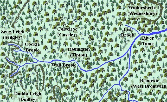
An impression of the area at the time of
colonisation.
Many local place names are Anglo-Saxon in origin, as can be
seen from the entries in the Domesday Book. Wednesbury is
recorded as Wadnesberie. The first part of the name (Wadnes)
refers to Woden the Saxon's god of war, and the second part
(berie) is derived from the old English byrig, meaning a
burgh, or burh, which is a fort. So the derivation of
Wednesbury appears to be Woden's fort. Many place names end
in 'ley' which comes from the old English word 'leah',
meaning a clearing. Sedgley means Secg's clearing, and
Dudley means Dudda's clearing. Others include Brierley Hill, Coseley, Cradley Heath, and the area of
Darlaston known as The Leys.
The old English word 'halh' meaning a pocket of land appears
in Willenhall, which means the meadowland of Willan. The
word "tun" meaning a settlement is found in Bilston,
Darlaston, Essington, Wolverhampton, and of course Tipton
itself. The old name for Tipton was 'Tibbington'. The middle
part of the name 'ing' simply means plural, so the name
refers to the settlement of the Tibbs, the surname of the
settling family, or their leader.
Tipton was in the southern part of 'The Hundred of Offlow',
which would have been headed by a hundred-man or hundred
elder, who oversaw justice and administration in the area,
organised the supply of soldiers, and led them into battle.
Hundreds were usually named after the place where meetings
where held, to discuss local issues, and where trials were
held. Offlow consists of two Old English words, 'Offa', a
person's name, and 'hlaw', a mound. So meetings were held at
Offa's mound.
After colonisation Tipton remained as a small farming
community for several hundred years. Around one sixth of the
land would have been cleared for farming, all that was
necessary to support such a small population. In Saxon and
Norman times there would have been just a few single-storey
timber-framed buildings, possibly clad with timber, or even
wattle and daub, and covered with a thatched, or turfed
roof. As timber would have been in plentiful supply, it was
an obvious building material. There would have been a hearth
for a fire, but no chimney (chimneys didn't appear here
until at least the late 14th century), the smoke escaped
through the roof. All the furniture such as beds, benches
and tables would have been made of wood. Valuable items and
tools would have been stored in a wooden chest.
Some Saxon houses were built above a hole, up to 9 feet
deep, which may have been a basement below a wooden floor.
The houses would have been surrounded by farmland for crops,
and grazing for cattle. |
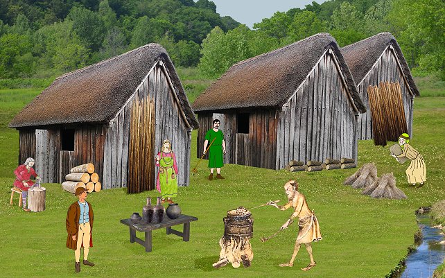
How the early village might have looked.
| Domesday After the Norman invasion in 1066, William the
Conqueror made it known that he personally owned all of the
land in the country. He appointed around 200 barons as
tenants in chief, and allowed them to hold large areas of
land, in exchange for the payment of taxes, and the
provision of soldiers when necessary. The system, known
later as feudalism was the key to the Norman's success.
The Normans held on to the Saxon 'Hundreds', but carved-up
the land into areas called manors, each controlled by a
Baron, or Norman Lord. They had to take an oath of loyalty
to the King, carry-out any required duties, and pay taxes
for their land. Each manor included several villages whose
inhabitants were called peasants. There were several classes
of peasant. The highest was a freeman who was free to pursue
a trade. The other classes were owned as part of the land,
and were not free to move around. Staffordshire came under the control of a Norman baron
called Ansculf de Picquigny who fortified the hill above
Dudley. Some time after 1070 he built the first Dudley
Castle, a motte and bailey structure, consisting of an
earthen mound topped with a timber tower, surrounded by a
defensive timber palisade. He was known as the Sheriff of
Buckingham, and lived until the mid 1080s. After his death
his son William Fitz Ansculf inherited his title and lands.
Although William Fitz Ansculf controlled the Black Country,
it seems that he had no interest in Tipton, possibly because
he considered it to be insignificant due to the tiny
population, and so lack of manpower, and lack of taxes etc.
In 1085 the Danes threatened to invade, and so King William
decided to commission a detailed audit of the country, to
extract all of the taxes owed to him, and to ensure that the
maximum number of soldiers were available to deal with the
expected invasion. The survey was so detailed that an entry
in the Anglo Saxon Chronicle states that 'not even an ox, or
a cow, or a swine was not set down in his writ.' It seemed
so invasive, and all-seeing, that it felt as though
judgement day had come. As a result it became known as the
Domesday Book.
All 400 pages of the book, record in extraordinary detail,
how the Normans organised their new kingdom. Everything on
the estate would have been owned and controlled by the
manor, or the clergy, including property, money, religion,
and even marriage. There were labour services to do on the
land, and heavy rents to be paid. The majority of food
produced, and animals reared were consumed by the lord of
the manor and his household. Many families lived off a
simple vegetable soup called pottage. The average life
expectancy at the time was just 25. The Domesday entry for
Tipton simply states that in Tibintone there are five
carucates of land that were held by the Bishop of Lichfield,
and were under the control of William. William was the son
of Warren (William Fitzwarren), and became the first lord of the manor of Tipton. A carucate is a piece of land of a size that can be ploughed
by a single plough in a year. It is generally reckoned to be
about 120 acres, so Tipton had about 600 acres of
arable land. It does not include meadow, woodland or
uncultivated land. There are no population figures, so the
population must have been extremely small. The arable land
would have been divided into strips, one for spring crops,
one for autumn crops, and another left fallow. They would
have been separated by broad grassy mounds. It has been
suggested that the original farming area would have been at
Tipton Green, hence the name. In 2011 archaeologists from
Museum
of London Archaeology carried out an excavation
in Shrubbery Avenue, Tipton Green
which yielded exciting new findings about the
medieval origins of the area. Pits, post holes and beam
slots were uncovered, along with 12th and 13th century
pottery, which is our best evidence for the location of the
early medieval settlement, as recorded in the Domesday Book. |
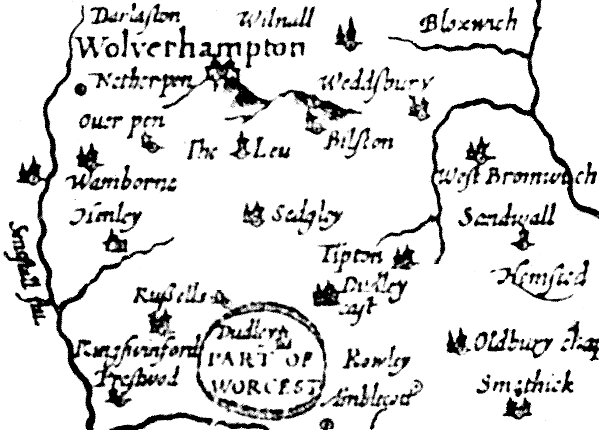
Part of a map of Staffordshire from 1610.
|
 |
|
|
|
Return to the
beginning |
|
Proceed to
Medieval Village |
|