Article originally published in West Midlands Archaeology 43 (2000), pages 29-32.

Introduction

When I took up the new post of Black Country Archaeologist in January 2000 it was soon obvious that one of the priorities was to take a fresh look at the archaeology of Wolverhampton and Walsall, as there were a number of development proposals for the central area of both settlements.  Studies of both towns had been published in the 1980s (Baker 1980; Gould 1982-3; Slater 1986; Baker 1988) but these needed updating in the light of more recent research and there was a particular priority to plot the extent of settlement onto the Black Country Sites and Monuments Record.  

The plans: Methodology

The methodology used for production of plans of the historic settlement areas was a familiar one of plotting features shown on early historic maps onto a later map base.  Advancements in technology over the last decade or so, however, mean that this exercise can now be carried out using a computerised mapping system.  The task was further simplified by the availability of the early Ordnance Survey maps in digital form so that the whole process could be carried out on computer rather than having to go through an intermediate phase of plotting on to paper maps.

For Wolverhampton we are fortunate in having an excellent mid-18th century plan of the town – Isaac Taylor's plan of 1750.  An attempt was made to fit this over a modern map base but it proved not to be sufficiently accurate to do so.  Accordingly measurements were taken off this map to fit features onto a map base provided by the late 19th century 1st edition Ordnance Survey plan.  Walsall is less well served but there is a valuable sketch plan of 1679 (Gregory King plan) and a more accurate survey of 1824 (Mason's plan) which were used to plot features onto the historic Ordnance Survey map base.  

The aim was to produce a map of settlement in each town at its greatest extent in the medieval period.  This would not necessarily be at the end of the medieval period as many medieval towns reached their maximum size around the end of the 13th century before the Black Death and catastrophes of the 14th century took their toll.  The problem of course is that there may have been substantial changes between the medieval period and the earliest mapping in the 17th to 18th centuries.  Again the techniques for distinguishing the earliest areas of settlement are familiar ones.  The historic core of an early town tends to comprise 'burgage tenements' with narrow frontages onto the street and long plots leading back from them.  A greater problem can arise at the edge of settlements where there may be smaller plots taken out of a town's commons or meadows.  It is easy to assume that these are late, post-medieval, additions but again we should not forget the population pressure in the 13th century.  Towns may reach an extent at this time that they do not approach again until the 19th century and they may expand in one direction, contact, and expand again in a different direction depending on the particular economic and tenurial circumstances of the time.  

The Results


Figure 1.

Despite the various caveats it is possible to produce plans of both towns and these are shown on Fig 1.  Apart from their value for development control they make they make an interesting comparison, both with each other and with medieval town plans elsewhere.  There is no evidence that either town had defences in the medieval period.  This is not uncommon.  In carrying out a survey of the historic towns of Cheshire I found no definite evidence of medieval defences at any towns there either, apart from those of the county town of Chester.  Nor were Wolverhampton and Walsall located at the foot a castle, as at the other major Black Country town of Dudley.  Instead the original centre of both towns was around their parish churches which were both set on ridges of high ground overlooking the surrounding area (although for Walsall Gould has suggested an earlier, pre-urban, nucleus around Town End).  Both towns  have evidence of deliberately laid out market streets with 'burgage tenements' fronting onto them.  Walsall was set either side of a water course – the Walsall or Town Brook.  A bridge is mentioned by around 1300 and a manorial mill lay adjacent.

Wolverhampton, however, unusually for a town, does not lie on a major watercourse.  There is only the Puddle Brook which runs along the southern edge of the settlement.

Conclusion

It is hoped that  future work in the town will help to refine and verify the town plans. 
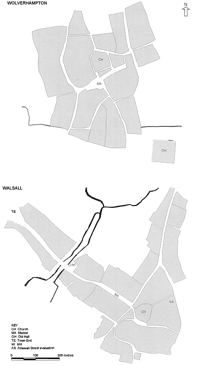
Hence the plans as presented here would show Wolverhampton and Walsall as a similar size, both around 22ha (54 acres) in area.  However, Wolverhampton was throughout the medieval period a considerably more important settlement than Walsall and it may be that the settlement area for Wolverhampton will need to be increased.  Nor has any attempt been made to distinguish phases of growth as Baker has done previously for Walsall.

Increased knowledge is likely to come from two sources: analysis of the documentary record and archaeological work.  Although both towns have lost early deposits over large areas through later development there is still potential for archaeological investigation.  Little archaeological excavation has been carried out in the past and, hence, even a small area of surviving deposits may tell us a great deal.  Work over the past 12 months has emphasized the potential.  Trial trenching in Wolverhampton on the site of the 'Old Hall', a medieval moated site on the edge of the town, has confirmed the survival of the moat ditch in one area.  In Walsall an evaluation at Ablewell Street revealed large areas of later disturbance but small islands of preservation, and two potentially early features – a ?hearth and a well, did survive.  It is hoped that a watching brief during development will reveal further features and provide dating evidence.

Hence the plans shown here are not the final story but they do provide a basis for defining future archaeological work which will in turn lead to the refinement and verification of the plans, while the flexibility provided by the computerised mapping system ensures that the plans can be easily amended as new information comes in.

References

Baker, N J 1980  The Archaeology of Wolverhampton

Baker, N J 1988  The Archaeology of Walsall

Gould, J 1982-3  Walsall-in the beginning. Trans South Staffs Archaeol Hist Soc 24, 1-7

Slater, T R 1986  Wolverhampton: central place to medieval borough, 29-47, in D. Hooke and T.R. Slater Anglo-Saxon Wolverhampton.  The town and its monastery.


Return to the
articles section