| With the end of the Second World War
almost in sight, Wolverhampton Council looked forward to a
bright future, which included a new and very different town
centre. In 1943 the Wolverhampton Reconstruction Committee
began planning a radical redevelopment of the town including
all aspects of its social, economic, and physical structure.
The committee looked at housing, transport, markets, a new
central library, a new civic centre, recreation facilities,
a new cemetery and crematorium, and general redevelopment.
The hope was to sort out some of the town’s acute problems
including inadequate housing, traffic congestion, run-down
central areas, and the lack of playing fields, parks, and
permanent allotments. The members of the Reconstruction Committee were as follows:
Councillor H. A. White (Chairman),
Councillor T. W. Phillipson (the Mayor)
Aldermen: A. Davies,
Sir Charles Mander, Bart., and R. E. Probert
Councillors:
Mrs. A. A. Braybrook, Mr. A. Byrne Quinn, Mr. W. H. Farmer,
Mr. A. G. Goodman, Mr. J. H. Hale, Mr. C. W. Hill, Mrs. R.
F. Ilsley, Mr. J. E. Jordan,
Mr. W. Lawley, and Mrs. M.
Mackay. |
The committee was assisted by a
sub-committee under the chairmanship of the Mayor, and also
by the Borough Engineer Mr. W. Mervyn Law who submitted many
reports, and Mr. J. Brock Allon the Town Clerk. A
comprehensive social and industrial survey was undertaken,
in co-operation with Birmingham University as part of a fact
finding exercise.
The town also co-operated with the
adjoining authorities of Tettenhall, Cannock, Wednesfield,
Willenhall and part of Seisdon in the formation of a
Wolverhampton and District Joint Planning Committee.
|
From a report produced by the Reconstruction
Committee.
|
Housing
It could be seen that the most urgent
and pressing post war problem would be the provision of
houses. In the inter-war years, 16,210 houses were built in
the town, which amounted to forty percent of the total
housing stock. This included 8,978 council houses. During
the same period, 4,342 slum and sub-standard properties had
been demolished under clearance schemes. No building work
had been carried out for several years, and it was estimated
that a minimum of 6,700 houses would be needed as soon as
possible. The aim was to build 1,000 houses a year, which
would depend upon the availability of material and labour,
and the construction methods employed.
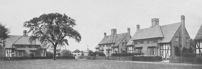
The Oxbarn Estate, a pre-war
development.
The houses were to be built following
the guidelines and plans in the 1944 Housing Manual,
published jointly by the Ministry of Health and the Ministry
of Works, and would include some temporary pre-fabricated
bungalows, four hundred of which had already been allocated
to the town. Two areas had been chosen for new housing
estates, one on the Willenhall Road where around 700 houses
were to be built, and another at Bushbury which would
consist of 1,400 homes. Plans included the construction of
roads and sewers, the provision of community buildings and
schools, and the provision of adequate playing fields in
close proximity to the houses. The retention of natural
features on the sites were an essential part of the design.
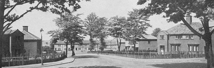
Another pre-war development, the Low
Hill Estate.
At the time, negotiations were in
progress for the acquisition of eighty five acres of rough
land between Willenhall Road and Deans Road for a third
housing estate.
Transport
Wolverhampton’s industrial development
depended upon ease of access to and from the town, for
people, raw materials and finished products. In the 1940s
there were ten major roads radiating from the town centre,
two railway stations and good depots, a network of canals
leading to the main ports, and a Municipal Airport. Shortly
before the outbreak of war, the Ministry of Transport
proposed a scheme for the building of a bypass to connect
Birmingham New Road with the A41, which could be extended to
join Stafford Road via Wobaston Road. This would have
diverted a considerable amount of through traffic, but could
have done little to relieve the congestion in the town
centre.
The increase in road
traffic between 1922 and 1938. The figures show
the average daily tonnage which is proportional
to the thickness of the black lines. From a
report produced by the Reconstruction Committee. |
The Reconstruction Committee felt that
the ideal solution would be the building of a central ring
road running from Penn Road in the south, along School
Street and Waterloo Road as far as Bath Road, then across to
Stafford Street and up Fryer Street to Victoria Square for
the bus station. The road would then go along Pipers Row,
and across to Cleveland Street, from where it joined the
Penn Road and School Street junction.
The road would provide
good access to all the major roads and the town centre. It would have an
overall width of 90 feet and consist of dual carriageways 22
feet wide, each with an 8 feet wide lay-by, allowing
standing traffic to pull-up outside the main carriageway.
There was also a central island that would be fenced so that
pedestrians could only cross the road at controlled
crossings. Roundabouts were to be constructed at each
junction, and frequent breaks in the central island would
allow traffic to turn from one carriageway to the other.
The proposed central ring
road. From a report produced by the Reconstruction
Committee. |
School Street, Waterloo Road, Fryer
Street, Pipers Row, and Cleveland Street were all to be
widened to accommodate the new road, and a new section would
be built between Wadham’s Hill and Stafford Street, and
between Stafford Street and Broad Street.
The Central
Library would be demolished to make way for the section of
the road between Pipers Row and Cleveland Street.
The main roads in and out of town were to be widened to 80 feet, and converted into dual carriageways.
The northern end of Penn
Road would be re-aligned, and Worcester Street would be
diverted. A new road would be built along Dunstall Hill from
Five Ways to Gorsebrook Road. |
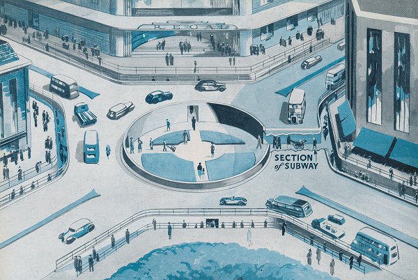
One of the proposed
roundabouts with a pedestrian subway. From a
report produced by the Reconstruction Committee. |
Central Redevelopment
A Civic Centre would be built in St.
Peter’s Square with an educational precinct between the
square and Stafford Street, which would include the technical college.
For many years there had been a lack of suitable office
accommodation for the Corporations’ administrative staff who
were housed in many separate buildings throughout the town.
It was felt that the building of a Civic Centre would
overcome this problem once and for all.
The scheme involved a great deal of
demolition, including all the buildings between St. Peter’s
Square and Queen Square, and Barclays Bank. All of the
buildings in North Street from the Town Hall to Queen Square
were also to be demolished, as was Gifford House and St.
Peter and St. Paul's Church. Cheapside and Exchange Street
would disappear, and the frontages along Darlington Street,
and the eastern side of Waterloo Road were to be
redeveloped.
From a report produced by the
Reconstruction Committee.
The Retail Market had passed its useful
structural life and was in need of extensive and expensive
repairs. It was felt that a suitable site for a new market
would be on the eastern side of Market Street where many
buildings were of poor quality. It would be near the town
centre shops, the new ring road, and the bus station.
There didn’t seem to be any advantage
in building a new Wholesale Market close to the Retail
Market. The main requirements for the Wholesale Market were adequate road and
rail access, so it was suggested that the new market
should be built on land between Guy Avenue and the
railway, which at the time contained extensive cold stores
operated by the Ministry of Food. There were several railway
sidings and enough land for the building of the market, a
cattle market, and abattoirs.
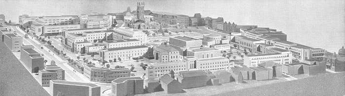
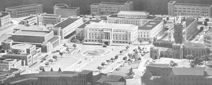
The council's model of the
proposed town centre development, looking across
Waterloo Road. On the right is Darlington Street
and the Methodist Church, in the background on
the right is Queen Square and Lichfield Street.
The central ring road is on the left. From a
report produced by the Reconstruction Committee. |
As already mentioned, the Central
Library would be demolished to make way for the ring road.
After careful consideration, the committee decided that a
new Central Library should be built on the site of the Town
Hall, in the same style as the Civic Centre.
St. Peter’s School and Institute would
be demolished to make way for the educational precinct,
allowing extensions to be built to the technical college,
along with a school of art, a little theatre with drama and
music facilities, and a county college.
The development of the new Civic Centre
would happen in five stages:
| 1. The erection of the greater part
of the administrative block, which would accommodate the
Corporation staff at present located in the Town Hall,
together with other staff distributed in the town
centre, such as Social Welfare, the portion of the
Medical Officer of Health’s staff in Exchange Street,
the Weights & Measures Department, etc. This block, which is situated on the
Market Patch, and on land in front of the present Education
Offices, could be erected without the removal of any
existing buildings, and it is recommended that it should be
proceeded with at the earliest opportunity. The completion of this portion of the
main block would place at the disposal of the police, ample
temporary accommodation in the existing Town Hall.
2. The demolition of the Retail Market
Hall and the Wholesale Market, and their erection on
alternative sites. The completion of the main
Administrative Block, and the erection of new police
buildings fronting a section of the proposed central ring
road.
3. Occupation of
new Police Buildings by the police, and
subsequent demolition of the existing Town
Hall, followed by the erection of the new Central
Library on the front portion of the site,
with provision for a car park
at the rear.
The construction of the northern
portion of the central ring road between Waterloo Road and
Stafford Street. The demolition of existing properties at
the corner of Darlington Street and Waterloo Road, and the
erection of new buildings on the site for the Electricity Show
Rooms.
4. The widening of Waterloo Road
between Darlington Street and Wadhams Hill to form part of
the central ring road. The demolition of existing property on
the east side of Waterloo Road between Darlington Street and
Wadhams Hill, and the erection of a new block of offices. The demolition of existing property on
the north side of Darlington Street between Waterloo Road
and Queen Square, and the erection of new premises
comprising shops with offices above.
5. Demolition of property between
Cheapside and Queen Square, the Conservative Club, Barclays
Bank, and Exchange Street properties.
|
|
The committee felt that the scheme
would be proof to future generations of the civic pride of
their generation, and would bring a greater sense of civic
responsibility to the local population.
The Civic Centre with a
fountain in front. On the left is the Central
Library and the Civic Hall, with St. Peter's
Church on the right. From a report produced by
the Reconstruction Committee. |
|
| |
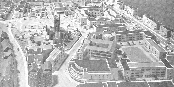
Looking towards the Civic Centre
with the Royal London Building in the foreground, and
the educational precinct on the right. From a report
produced by the Reconstruction Committee. |
|
Recreational Facilities
The committee looked at existing
recreational facilities, and thought that Wolverhampton
suffered from a considerable deficiency for a town of its
size. In order to rectify the situation, a further 455 acres
of parks, playing fields, and playgrounds were required,
together with a further 270 acres of school playing fields.
It was realised that it was impracticable to obtain such a
large area within the town, other than by a long term
planning policy. Some areas were proposed, including what is
now Windsor Avenue Playing Fields, and Manor Road Park at
Penn, and also part of the Colton Hills, also at Penn.
The ultimate aim was to ensure that
everyone had at least one park within easy walking distance,
and each child had a playground in easy reach, without
having to cross a main road. It was felt that the amenities
in existing parks and playing fields should be improved by
planting trees and shrubs to screen the backs of adjoining
houses, and the provision of sand pits and
paddling pools for children. The larger parks and
recreational areas should have pavilions, toilets, and a
better provision of seats and shelters. Improvements to East
Park should include a boating lake, and an extension to Stow
Heath Lane.
Allotments
At the time, around 4,500 temporary
allotments were in use to help with wartime food shortages.
Few of these were expected to survive after the war, when
the land would be used for other purposes. There were also
4,621 privately owned allotments in the town. It was hoped
that after the war, a sufficient number of permanent
allotments would be available to cope with the expected demand.
A New Cemetery and Crematorium
It was realised that the existing space
at Jeffcock Road Cemetery would soon be used up, and so
steps were taken to acquire 45½ acres of land on the side of
Bushbury Hill on which to build a modern crematorium and to
lay out a lawn cemetery.
|
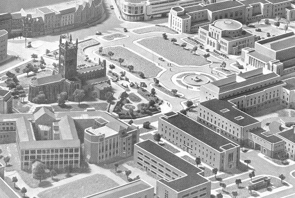
A final view of the proposed
development, looking across the technical college to
Queen Square. From a report produced by the
Reconstruction Committee. |
|
Conclusion
The cost of such a bold and
comprehensive scheme would be formidable, and could only be
carried out with the support of the general public. The
committee clearly felt that the plan would greatly benefit
the local community, and improve people’s lives.
Outcome
The plans were never implemented
because of financial restrictions, but many of the
committee’s suggestions have come to pass. The Civic Centre
is built on more or less the same site as proposed by the
committee. The Ring Road has many similarities with the
central ring road, and the educational precinct consists of
extensions to the university, and the university’s School of
Creative Arts and Design. The markets have moved, as has St.
Peter’s School, and the Police Station. The large post war
housing schemes came to fruition, as did some of the
suggestions for recreational facilities.
Luckily we still have some of the
lovely buildings that would have disappeared had the plans
been put into practice, including the old Town Hall, Giffard
House and church, Barclays Bank, and all the old buildings
on the northern side of Queen Square, and in Exchange Street
and North Street.
People still talk about the impact of
the Mander Centre in the 1960s and 1970s, and the important
losses that resulted from it. Arguably, if the scheme had
been implemented, the losses would have been far greater,
and still talked about today.
|
 |
Return to
the
previous page |
|