|
 |
Mining
In the late
thirteenth and early fourteenth centuries, the first
noticeable signs of industrialisation in the Black
Country started to
appear. An inquisition post mortem in 1273 records that
there were four coal pits in the manor of Sedgley, and
another in 1299 includes a reference to the mining of iron
ore. In 1273 there were sixteen shops in Sedgley, believed
to be involved in metal working.
Many early records relating to
Wednesbury still survive. It is possible that coal was being
dug in Wednesbury as early as 1286 because in that year
Tandy de la Coldelvere was charged with creating an
enclosure of land within the local woods, then part of
Cannock Forest. This was an infringement of Forest Law. If
the name Coldelvere meant coal digger, this is the first
reference to coal mining in the area.
An important record of life in medieval
Wednesbury in 1315 is the Assignment of Dower of Juliana
Heronville, who was entitled to one third of the manor of
Wednesbury after the death of her husband, lord of the
manor, John de Heronville. After his death one third of the
manor was left to Juliana, and two thirds were left to
Henry, the son of John’s first wife. The document includes
details of an iron mine valued at six shillings a year. This
is the first record of iron ore mining in the town.
The assignment also gives details of
several coal pits, and as such is the earliest record of
coal mining in the town. It is likely that the fourteenth
century pits in Wednesbury were near Broad Waters. In some
areas the 10 yard coal seam outcrops at, or very near the
surface, and this is where the first coal would probably have
been extracted. In the 15th century, Cockheath was named as
a coal mining area.
In 1377 John Waters of Wednesbury sued
Roger Hillary for taking coal to the value of forty pounds
from his mines in Wednesbury. In 1392 John Wylkys sued Roger
Norton of Darlaston for digging and taking away coal from
his land to the value of £10.
There are other early records of mining
in the area. Much of Walsall lies in the South Staffordshire
and Cannock Chase coalfields, where coal often outcrops
close to the surface. By the early fourteenth century, coal
and iron ore were being mined in the town. The lords of the
divided manor, Roger de Morteyn, and Margery Ruffus made an
agreement to share the profits of the coal and ironstone
mines in the manor. Margery’s son, Sir Thomas le Rous
reserved the right to license coal-mining on land at
Birchills in 1326 and 1327. By the late 1380s, and 1390s,
there were coal and ironstone mines in Windmill field. There
were also coal mines at Bradley in 1315, at 'le Hayeschute'
near Wednesfield in 1325, and at Bilston by 1401. |
|
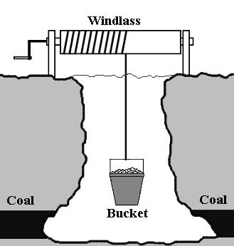
A bell pit with hand-winding gear. |
Much of the early coal and iron ore extraction would
have taken place where the seams are near the surface,
so that shallow, open-cast workings were all that was
necessary. When these were worked-out, people dug bell
pits, unsupported structures going maybe twenty five
feet down, into the coal and ironstone measures.
At the bottom, as much material would be extracted as
possible before the structure became unsafe. It was then
abandoned, and a new shaft dug nearby.
In this way, large areas became covered with old pit
shafts which slowly filled with water and collapsed. As
a child I remember seeing what was left of this
landscape at Bentley. There were small grass-covered
hillocks and mounds everywhere, and many small pools
covering flooded workings. |
|
As mentioned earlier, no early records
exist for Darlaston, and so it is not known when mining began
in the town. In 1538 when the traveller, historian, and
writer John Leland travelled through Birmingham and the
Black Country, he made no reference to Darlaston, and so it
may be that little, if any, industrialisation was taking
place in the town at the time.
For over two hundred years the iron ore
was mined for the production of the fairly low grade iron
used by numerous blacksmiths in the area. By the second half
of the sixteenth century coal was beginning to be used for
domestic heating, due to the shortage of timber.
Early mining in Darlaston appears to
have been concentrated in the thick seam of coal that runs
from Bilston and curves in an arc through Moxley and the
southern part of Darlaston, before running southwards into
Wednesbury. The seam was often around thirty feet thick and
became known as ‘the ten yard seam’. By the late seventeenth
century, exploitation of this seam would have greatly
changed the local landscape. For the first time, parts of
Darlaston would have looked like an industrial area rather
than open countryside.
In 1698, Timothy Woodhouse, who was
manager of the coal mines belonging to Mrs Mary Offley, the
Lady of the Manor, had a two year contract and was paid
twenty pounds a year for maintaining the mining buildings,
looking after the horses, collecting arrears, hiring
colliers, and organising sales. In the first year he sold
3,000 sacks of coal, and later went into partnership in his
own business.
Another record from around the same
time states that Edward Blakemore, a nailer, who had a
milking cow, barley, winter corn, and land, was owed thirty
pounds by Mrs Mary Offley for coal, and expected that his
executors would go to law to recover it.
One surviving document dated 1750,
concerns a letter from Darlaston coal mine under-manager,
Joseph Lytcott, to the owner of the mine. With the aid of a map, he
advises the owner, not to sink any shafts in the vicinity of
Clarke's Close, because of the danger of meeting other
workings underground, which could cause flooding.
|
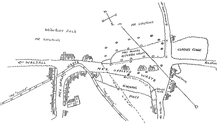
Joseph Lytcott's map.
|
I think it advisable that a pitt be
sunk in the lane leading to Birmingham and that they drive a
road by the lane side along Mrs. Cookes’ hedge to prevent or
discourage her getting coal under the lane, for I understand
she's one that will loose nothing she can get by any means
fare or fowl. I have picked the place in the lane as you
will see between x..............x if they sink and work in
Clarke's Close all the water in Cookes and some of Shiltons
must inevitably come upon in as you may see by the drop of
the coal, and if the road I speak on be driven to secure
Mrs. Cookes forthwith as may be done it must be while she's
working and then she will drain the water from us - if she
have any and if you approve of this I will write to Mr. Wood
to say I goe for London and call at my coming down to see
whether it be performed.
Joseph Lytcott
Clarke's Close was an area of about six
acres, containing twenty three pits, of which seven were
at work. The shafts were closely spaced as can be seen from
the sketch. At Kitchen Croft they where not more than fifty
yards apart. This is a clue to the type of pits being
worked, namely bell pits, as the limit for underground
working would have been within about a twenty five yard
radius from the shaft. The leap marked on the sketch is
probably a fault, and a sough was a drain to remove water
from the mines. The road to Birmingham is Dangerfield Lane,
the road to Bilston is Moxley Road, the road to
Wolverhampton is Wolverhampton Street, and in the bottom
left hand corner is Saint Lawrence's Church.
Other collieries in close proximity
included Russian Colliery, near to where Pinfold Street
Primary School now stands, Mill Colliery, near to where Mill
Street is today, Lodge Holes Colliery, off Dangerfield Lane,
and Herbert’s Park Colliery on the site of George Rose Park.
There were many, many, small pits throughout much of
Darlaston, which encircled the town centre, and changed the
landscape forever.
|
 |
|
|
|
|
Return to the
Farming Community |
|
Return to
contents |
|
Proceed to
Early Iron-Making |
|