|
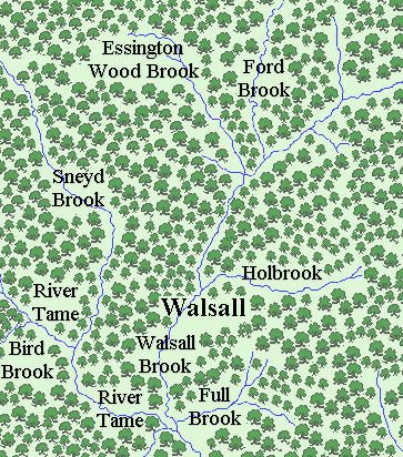
Walsall lies partly on the South
Staffordshire coalfield above the thick Carboniferous
coal measures, and partly above Silurian limestone,
which forms the hill where St. Matthew’s church now
stands. There are also Silurian shales in the south
west, and glacial deposits consisting of boulder clay,
sand, and gravel. The area was once thickly wooded, and
formed part of Cannock forest.
All traces of the town’s origin
have long disappeared. The activities of the ancient
Britons and the Romans must have been limited due to the
thick vegetation that covered the area. Ancient flint
tools have been found at Bourne Pool in Aldridge, and an
ancient burial mound stood at Catshill in Brownhills.
The Romans were certainly in the
locality, and left their mark in the form of Watling
Street, which skirts the northern edge of the town, and
Wall, the Roman fort on the southern edge of Lichfield.
Wall, originally called Letotceum, provided
accommodation and a change of horses for travellers, and
had an inn and a bath house. Several Roman coins from
the first century were discovered in Wednesbury, as was
a piece of Roman glass. Other Roman coins have been
found in Bilston, Perry Barr, and Stonnall near Walsall
Wood. There was also a Roman Road called Ricknield
Street, after which Streetly is named. The line of it
can still be seen in Sutton Park, running from Chester
Road North to near the junction of Thornhill Road and
Streetly Lane.
Walsall’s story really begins when
this part of the country was colonised in the 6th
century. After the Roman army had departed, the country
became a frequent target for raids from France, The
Netherlands, Germany and Denmark. Angles and Saxons from
Northern Germany were employed as mercenaries for
protection, and often given farmland in return for their
services. Many of them brought their families with them,
and slowly began to colonise England, moving northwards,
and westwards. By the 9th century there were three
competing kingdoms, Mercia, Northumbria, and Wessex.
South Staffordshire was part of
Mercia, a word derived from the Old English “Mierce”
meaning people of the boundaries. A tribe called the
Anglian Mercens moved southwards, following the Trent
Valley and its tributaries, such as the River Tame
(meaning the dark river). They were the first settlers
in the area, known as the Tomsaete (dwellers by the
Tame). They would have cleared areas of the forest for
their cattle and crops, and lived in simple timber
framed, and possibly timber clad buildings (timber being
in plentiful supply). The Old English word for a
woodland clearing is “leah” which appears in several
local place names including Bentley, Coseley, Sedgley,
and “The Leys” at Darlaston, all pointing to their
Anglo-Saxon roots.
Many other local place names tell
of their Anglo-Saxon roots. Aldridge is listed as
Alrewic in the Domesday Book, a Saxon name meaning
'Alder village', suggesting that a lot of alder trees
grew in the area. Bloxwich (Blochescwic) means "Bloc's
village", and Darlaston means Deorlaf’s Tun, or town,
possibly the name of the leader of the first tribe to
settle there. Pelsall was first mentioned in Lady
Wulfrun’s charter of 994, in which she gave land to the
monastery at Heantune (Wolverhampton). It was called
Peolshalh, which means an area of land belonging to Peol.
Rushall is also Anglo-Saxon, meaning a place in marshy
ground where rushes grow, and Willenhall was referred to
as “Willenhalch” in the eighth century, meaning the
meadowland of Willan. |
|
6th century Walsall. |
The earliest reference to Walsall
is thought to be in Wulfric Spot’s will dated 1002 to
1004. He was one of the three known children of the
noblewoman Wulfrun, after whom Wolverhampton is named.
He died at the battle of Ringmere,
some time between 1002, when his will was made, and
1004, when King Æthelred issued his charter to approve
it.
The will refers to a place called 'Walesho',
which is believed to refer to Walsall.
The name next appears in a charter
made by Henry II in 1159, granting the Manor of Walsall
to Herbert Ruffus.
In the charter Walsall is called
Waleshala which probably has Anglo-Saxon origins,
consisting of two words, ‘Wealh’ meaning a Briton or
Welshman, and ‘halh’ meaning a sheltered place. |
|
The capital of the Kingdom of
Mercia was Tamworth, which was replaced by Stafford in
913 when it became a secure, fortified stronghold, under
Queen Aethelfaed. Within a few years the Shire of
Stafford was formed, which was divided into 5
‘Hundreds’, each consisting of an area roughly
supporting 100 households. They were Cuttlestone, Offlow,
Pirehill, Seisdon and Totmonslow. Walsall was in the
southern part of The Hundred of Offlow, which would have
been headed by a hundred-man or hundred elder, who
oversaw justice and administration in the area,
organised the supply of soldiers, and led them into
battle. Hundreds were usually named after the place
where meetings were held to discuss local issues, and
where trials took place. Offlow consists of two Old
English words, ‘Offa’, a person’s name, and ‘hlaw’, a
mound. So meetings were held at Offa’s mound.
It has been suggested that Church
Hill, where St. Matthew’s Church now stands was once the
site of a hill fort. There is no archaeological evidence
to support this theory because the hill has been
subjected to many building schemes throughout the
centuries, which have destroyed any remnants of early
earthworks or fortifications. However, two street names
do refer to fortifications. Ablewell Street, or Avalwall
Street is from an old Norman word meaning ‘below the
wall’ suggesting a fortification, and The Ditch appears
to commemorate a ditch, possibly dug as a part of a
fortification. As the hill is the highest point in the
immediate vicinity, it would have been an ideal site for
a settlement that could have been fortified, but all of
this is pure conjecture.
After the Norman invasion in 1066,
William the Conqueror made it known that he personally
owned all of the land in the country. He appointed
around 200 barons as tenants in chief, and allowed them
to hold large areas of land, in exchange for the payment
of taxes, and the provision of soldiers when necessary.
The system, known later as feudalism was the key to the
Norman’s success.
The Normans held on to the Saxon
‘Hundreds’, but carved-up the land into areas called
manors, each controlled by a Baron, or Norman Lord. They
had to take an oath of loyalty to the King, carry-out
any required duties, and pay taxes for their land. Each
manor would include several villages whose inhabitants
were called peasants. There were several classes of
peasant. The highest was a freeman who was free to
pursue a trade. The other classes were owned as part of
the land, and were not free to move around.
Staffordshire came under the
control of a Norman baron called Ansculf de Picquigny
whose lands included Berkshire, Buckinghamshire,
Hertfordshire, Middlesex, Northants, Oxfordshire,
Rutland, Surrey, Worcestershire, and Warwickshire. He
decided to fortify the hill above Dudley as his
headquarters, and sometime after 1070 built the first
Dudley Castle, a motte and bailey structure, consisting
of an earthen mound topped with a timber tower,
surrounded by a defensive timber palisade. He was known
as the Sheriff of Buckingham, and lived until the mid
1080s. After his death his son William Fitz Ansculf
inherited his title and lands.
In 1085 the Danes threatened to
invade, and so William decided to commission a detailed
audit of the country, to extract all of the taxes owed
to him, and to ensure that the maximum number of
soldiers were available to deal with the expected
invasion. The survey was so detailed that an entry in
the Anglo Saxon Chronicle states that ‘not even an ox,
or a cow, or a swine was not set down in his writ.’ It
seemed so invasive, and all-seeing, that it felt as
though judgement day had come. As a result it became
known as the Domesday Book.
All 400 pages of the book, record
in extraordinary detail, how the Normans organised their
new kingdom. Everything on the estate would have been
owned and controlled by the manor, or the clergy,
including property, money, religion, and even marriage.
There were labour services to do on the land, and heavy
rents to be paid. The majority of food produced, and
animals reared were consumed by the lord of the manor
and his household. Many families lived off a simple
vegetable soup called pottage. The average life
expectancy at the time was just 25. |
|
Although the Domesday Book was
incredibly detailed, some places seem to have been
overlooked, or the entries mislaid. Much has been made
of the fact that Walsall does not appear in the Domesday
Book, possibly due to a clerical error, but neither does
neighbouring Darlaston, or Burton-on-Trent, Stone,
Colwich, and Newcastle-under-Lyme. Some parts of the
modern borough do appear in the book. They are Bloxwich,
Aldridge, Pelsall, Rushall, and Willenhall.
William Fitz Ansculf’s daughter,
Beatrice, appears to have married Fulk Paganel, who
inherited Dudley castle. He in turn was succeeded by his
son Ralph, who in turn was succeeded by his son Gervase.
In 1160 Gervase Paganel founded the priory at Dudley in
memory of his father, and in 1173 took part in an
unsuccessful rebellion against Henry II, who in return
demolished Dudley Castle.
In 1159 Henry II was in France
attacking Nantes and Toulouse during his French
campaign. In June, whilst at Saintes in Saintonge, he
granted a charter to one of his loyal knights, Herbert
Ruffus, giving him the Manor of Walesale, possibly as a
reward for his military service. The surname Ruffus
means ‘The Red’.
This is the earliest document
relating to the manor, and is translated from the
original Latin as follows: |
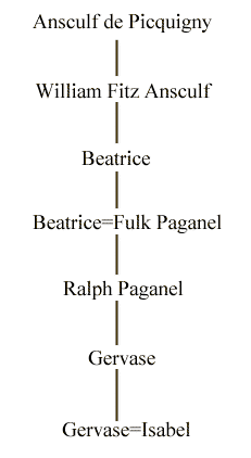
The local Norman Lords. |
|
Charter of Henry II made to Herbert Ruffus,
of the Manor of Walesala
Henry, King of England
and Duke of Normandy, and Aquitaine and
Count of Anjou, to his Archbishops, Bishops,
Abbots, Earls, Barons, Justices, Sheriffs,
Servants, and all others his liege subjects,
both French and English, throughout the
whole of England, greeting. Know ye that I
have granted and confirmed to Herbert Ruffus
(Rous) my servant and his heirs Walesala
with all its appurtenances. Rendering to me
£4 yearly, for custody and account for all
services. Wherefore I will and strictly
enjoin that Herbert and his heirs after him
shall have and hold the land aforesaid,
truly and peaceably, freely, quietly,
honourably and wholly, with all its
appurtenances, in wood and in plain, in
meadows and pastures, in ways and byeways,
in water, in mills, and in all places, and
in all things, and with all liberties and
free customs belonging to the same.
|
Witnesses: |
Thomas,
The Chancellor.
Richard De Luci, Custom Fermor
of Windsor.
Henry Fitzgerald, Chamberlaine.
Richard De Camville.
Robert De Dunstanville. |
At Santone
(Apud Santoniam) |
|
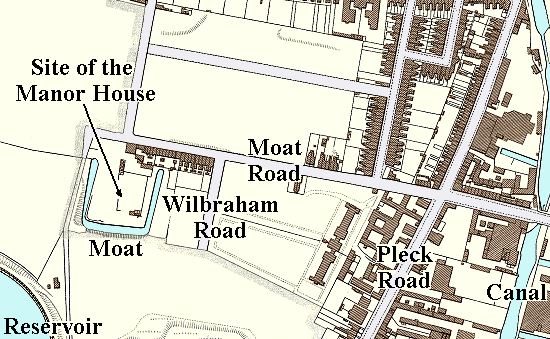 |
The location of Walsall Manor
House and moat. Parts of
the moat survived until the early 1970s, after which the
area was covered by an extension to the Manor Hospital. |
|
The Manor remained in the hands of
the Ruffus family until the early 14th century. The site
of the manor house is now occupied by an extension to
the Manor Hospital. In 1974, before building work began,
an archaeological survey was carried out on the site of
the house and what remained of the moat. From the survey
it was concluded that the earliest building on the site
dated from the beginning of the 13th century, and was
constructed on land that had previously been cultivated.
Part of the building had initially been used for metalworking,
before being extended. By the late 1330s the moat
had been dug. |
 |
|
|
Return to
the beginning |
|
Proceed to The Medieval Village |
|