A Tale of Two Squares: St. John's and St. James
by Maureen Hunt,
with photos by David Clare
and additions by Bev Parker
This is the story of two squares in Wolverhampton, one of which survives, the
other does not. What is their story? And why did one survive and not the other?
St. John's Square is situated near the top of Snow Hill, and is still a
busy place, thanks to the many offices and businesses that are based there. St. James'
Square, near the west end of Horseley Fields, disappeared in the 1960s, and has
since been almost forgotten.
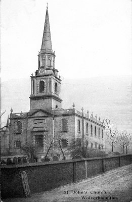
This early twentieth century postcard
shows St. John's church and the high brick wall which hid the
gravestones from the residents' view. |
The origins of the
squares and the two churches
St. John's Church is the second oldest church in the City
Centre, and the first to be built within its own square.
By the mid eighteenth century the population had increased to such an extent that another church was
urgently needed. The site chosen for the building, lay to the
south of the town in almost open countryside, as can be seen
from Isaac Taylor's map
of 1750. The area is marked as 'Windmill Bank' and the 'Cock
Closes'.
St. John's Church was built under the terms an Act of
Parliament, passed in 1755 which allowed a fourth chapel of ease
to St. Peter's Church to be set-up. The first chapel of ease
was built
at Wednesfield in 1746, followed by one at Willenhall in 1748, and
another at Bilston in 1753.
Although details of the plan are not clear, it seems that the
new church was intended to serve an area likely to see
expansion. Snow Hill and the surrounding streets were rapidly
being developed, as the town extended southwards.
The church opened, although not complete, in 1760, and the
buildings around the square slowly appeared during the next 100 years or so. |
| The fact that
four roads meet the square in a symmetrical way (Church Street,
Bond Street, George Street and a short street opposite Bond
Street leading to Church Lane) strongly suggests development
according to a plan. The square seems to have began life as an
elegant secluded square, echoing the lovely Georgian buildings
in George Street, at the eastern end. As time progressed,
buildings of a lower standard were added, giving the a square a
haphazard appearance. |
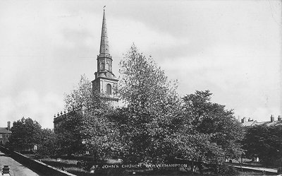
A later postcard shows the church and
the wall on the other side of the square. To the right the
houses of the square can just be made out. |
| By the early 1830s the western end of the square around
Church Street became industrialised when James Tonks & Sons
opened their brass foundry. This was followed by the
building of a number of small workshops at the eastern end
of Church Street, which included a coal yard. |
|
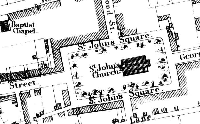
From the 1842 Tithe map, showing the
nearly fully developed square. |
| St. John's Square, as its name implies, is a square surrounding a church of the same name. But St.
James' Square existed at least 50 years before St.
James' church was built. The square was a few hundred
yards away from the church, which seems to have taken its name
from the square, rather than the other way around.
Local historian John Roper, described it as follows: "The name of this area of the town has baffled historians. Long
before the church was built, the large Georgian Square was known as St.
James' Square, but there is no record of any connection with this particular saint
in the Middle Ages." The Square was not exactly square and it had only two streets leading to it,
one from the north-west corner leading to Horseley Fields and the other from
near the south-east corner leading to Union Street. |
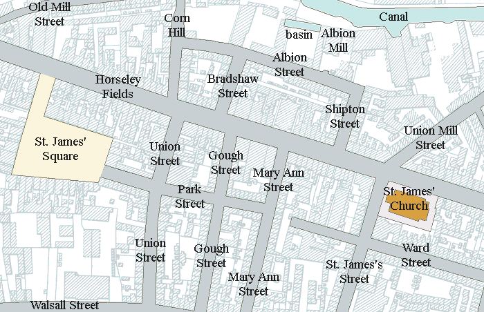
The location of St. James' Square, and the not too distant
St. James' Church, which may have been so named because of
its proximity to the square. |
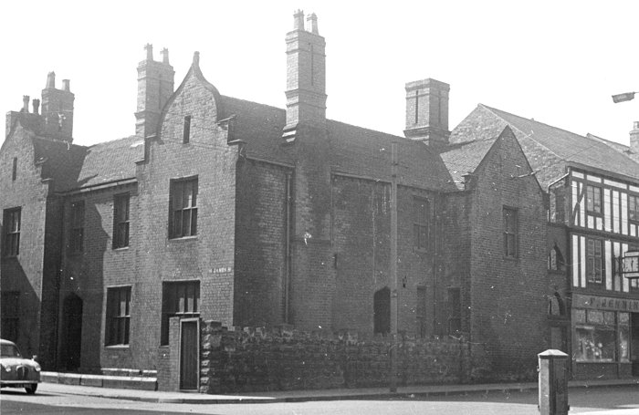
St. James' Vicarage in St. James
Street. The above photograph,
taken from the north side of Horseley Fields, shows the
vicarage on the corner. Courtesy of Roger Jennings. |
| The first map showing both of these areas is Godson's map of Wolverhampton.
This map, dated 1788, although of poor quality, gives the names of all the
streets in Wolverhampton at that time, together with the number of houses and
their inhabitants. Although by this date St. John's church had been built for
some time, there as yet were no dwellings in the Square itself, though Bond
Street, leading from Temple Street through to the church, is mentioned as having
nine dwellings and forty inhabitants. Meanwhile, on the other side of the town, St. James's Church was still fifty
years away from being built; but St. James' Square was already in existence and
it too had nine houses and forty inhabitants. This may suggest that, as a
residential square, St. James' had at least chronological priority. Indeed the
general direction of development seems to have been much more towards the east
than the south, which must have been considerably assisted by the opening of
the canal in 1772.
By 1792, as shown in the Wolverhampton Rate Book, there are still no houses
in St. John's Square, but Bond Street seems to have grown. The nine dwellings
have increased in number to fifteen. St. James' Square has five commercial premises
mentioned:
Joseph Sapwell, bucklemaker
Obadiah
Walford, victualler
John Millington, keymaker. No. 2 St. James' Square.
Thomas
Evan, joiner and huxter
John
Cadwallader, locksmith. No. 9 St. James' Square. |
|
|
| The squares in the nineteenth century By 1809-11 the trade directory still does not mention St. John's Square, but
now, as well as Bond Street, George Street is listed. This indicates that at
around this time, the link road between St. John's Church and Snow Hill was
being developed. In this particular directory, St. James' Square is not
mentioned either. But a "Horseley Fields Square" is. Presumably this was the
same square. |
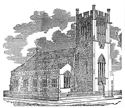
St. James Church, built in the gothic style. The architect was a
Mr. Egington and the builder, a Mr. Snow of Leamington. |
St. James' Church was built between 1840 and 1843. It was consecrated on 12th
May, 1843, and had north and south galleries, and a west gallery for the organ.
It had a single bell in the tower, and could seat 1,200 people. The vicarage was
built in 1847 at a cost of £1,100.
The church was renovated in 1924, at considerable cost, and an oak choir
screen was added in 1929.
By the 1950s the size of the congregation rapidly fell, which led to the
closure of the church and its demolition in 1955. |
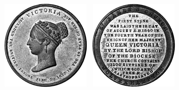
The commemorative medal struck for the
laying of the church foundation stone in 1840. Courtesy of David
Clare. |
| A property sale advertisement in the Chronicle in 1817, gives a clue to the
building of the first houses in St. John's Square. The advertisement refers to
the sale of three dwelling houses in St. John's Square and Bond Street, and a newly
erected dwelling house in St. John's Square "together with the school thereto
adjoining". So this is presumably the time that the Square began to take shape. Coincidentally, appearing in the same newspaper was an advert for sale of a very
large amount of timber, the property of Obadiah Walford, victualler of St. James' Square. Clearly Obadiah was not just a licensed victualler. As the
timber appears to be on the premises in St. James' Square,
we perhaps have an indication that the square and its area
were already becoming more commercial and less residential
than St. John's. |
|
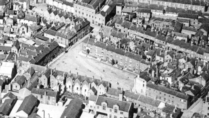
St. James' Square. Courtesy of
David Clare. |
| In 1840 the two churches, St. John's and St. James, became
linked together for a day. The date was Tuesday the 18th August 1840. That was
the day the foundation stone for St. James' Church was laid. The Chronicle for 19th
August had an extensive report of the proceedings, which occupied almost a whole
day, starting with a service at St. Peter's, with the Bishop of Lichfield in
attendance. Refreshments were then taken, and by 4.30 a procession had assembled
at St. John's, from where it proceeded, on foot, to the site of St. James'
Church,
nearly a mile away. The Chronicle noted that "his lordship, who wore his episcopal habit, was an object of considerable curiosity to the crowd, who
completely lined the way from George Street to Horseley Fields". He formally laid the foundation stone, then hopped up onto it to address
the crowd. In his address he refereed to the "spiritual destitution" of this
part of the town and the need for the church. When he had finished these few
kind words, the Rev. W. Dalton made a speech in which he also "forcibly
portrayed the spiritual destitution of the town". A crowd of "several thousand
people, who appeared to take a lively interest in the day's proceedings,"
then dispersed. |
| |
|
|
|
|
View a list of
inhabitants in 1851 |
 |
|
View the
1879-80
electoral register |
 |
| |
|
|
|
|
|
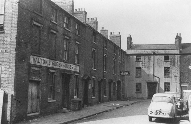
The north-western corner of St. John's
Square. Courtesy of David Clare. |
| Melville & Company's Wolverhampton Directory of 1851 shows that
St. John's Square seems to have been quite a fashionable part of
Wolverhampton to live in. Under the heading of "Gentry" there
are 6 people listed as well as a professor of music (who was
also the organist of St. John's), a portrait and historical
painter, two school masters, a dressmaker and a furrier. In addition there were two boarding houses, a ladies seminary, and a
classical & commercial school. Samuel Tonks is also listed. He was the owner
of the brass and bell foundry at the western end of the Square, and lived in Church Street. Also listed was "James Gibbons,
factor, St. John's Square." St. James' Square, at this time, only had one person listed under the
heading "Gentry", while the rest of the Square's 32 dwellings were occupied by
roughly the same professions as its counterpart. It too boasted of two ladies
schools, two teachers, a day and evening school (run by Charles Trevor) and
Monsieur Willenboard Buscot, a professor of the French language. John Fell & Co.
were the Brass Founders of this Square. The notable ale
house in St. James's
Square was the George Inn, sometimes referred to as the "George III".
In 1851 John Lane was the victualler.
As well as the same respectable trades, as in St. John's Square, St.
James' had two coal merchants and two corn and seed merchants. Perhaps these
last two trades were carried on in this Square because of its close proximity to
both the canal and railway.
The electoral register for 1879/80 shows that St. John's Square was still
holding on to its status, with a surprisingly similar list of occupations to
that of 1851.
The squares in the twentieth century
In the 1901 Red Book there were seven people listed under "Private" in St.
John's Square. Other listings of interest are the "Central Registry Office" and,
under the heading of "India Rubber Goods Merchants", is the "Wearwell Cycle
Accessories Co". Also shown is A. G. Haselock (jnr), a file and rasp manufacturer. There were three credit drapers, no less than three professors of music,
and a pianoforte dealer. The square was probably becoming more commercial and
less residential with the continued expansion of Wolverhampton as an industrial
centre, and the development for industrial purposes of the land south of the
square.
No "Private Residents" at all are listed for St.
James' Square in 1901. There were only six trades people
noted:
Wootton Bros., nail & cut
tack manufacturers
Mulliner & Co., paper box
manufacturers, and printers
Cozens W & Co., provisions merchants
J.
Fell & Co., brass founders
Wing & Webb, hardware merchant
M. A. Voyce, licensed victualler,
"George III" |
|
The George III pub was still in existence, and Mulliners, the
printers, and Cozens, provision merchants, were also there. The three of them remained
in the square right up until its demolition. By 1930, surprisingly enough, some of the families living there are still the
same, but again this is more noticeably so in St. John's Square than in St.
James'. |
|
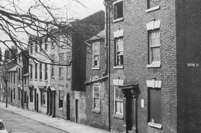
The northern side of St. John's Square.
Courtesy of David Clare. |
| By the year 1948, both squares were becoming
decidedly rundown. In the Wolverhampton Chronicle, dated 15th April,
1948, an article by Kenneth Bird was already lamenting "the drab
facades of the buildings and the pervading air of decayed
elegance" of St. John's Square. He attributed the square's
descent in the world to the building of galvanising plants in
the vicinity, and the power of the car to sweep people out into
suburbia. |
|
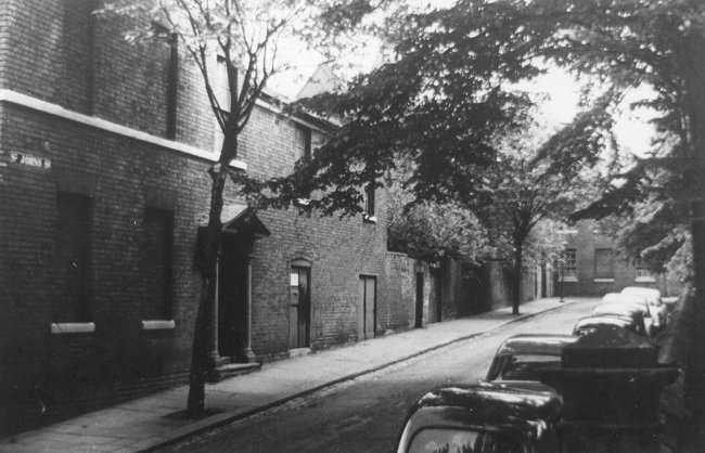
The north-eastern corner of St. John's
Square. Courtesy of David Clare. |
| The vicar, the Reverend J. Hartill, complained to him of vandalism, the use
of the stained glass windows in St. John's Church for catapult practice, and "acts of
horrible desecration", with piles of refuse in the churchyard and the vaults
smashed. He blamed local children.
A local business man, Mr. M. H. Costley, who
operated an export business from the church end of George Street, told Bird: "I
can remember this square 60 years ago (about 1888), and things were very
different then. I used to go to school in the square. The master was a man named Bratt, who didn't believe in sparing the rod. Mischievousness or a failure to
master the principles of reading, writing and arithmetic lead to a good
thrashing across one of the desks. He was a real old-fashioned pedagogue, with a
high collar and a bow tie.
When I walked to school I used to watch the horses
drawing phaetons away from the bigger houses. It was a very picturesque sight.
In particular I used to take notice of Mr. Richard Briscoe, founder of a now
famous business house. He was a most imposing gentleman who used to live at 10
George Street. Later he moved to Chillington Hall".
Another local, Mrs. E.
Hall, insisted that the neglect was comparatively recent, apparently in the last
twenty years or so. |
|
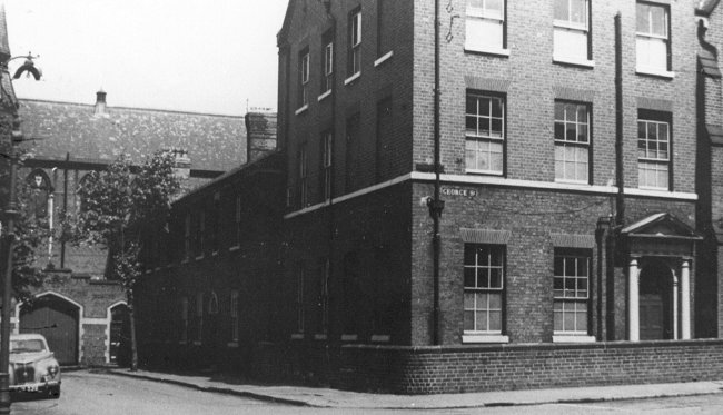
Another view of the north-eastern corner
of St. John's Square. Courtesy of David Clare. |
| The electoral registers of 1955,
show to what extent the Squares' population had dropped in
number. St. John's still had thirty-five addresses registered as
having voters living there, while St. James' Square had only
three.
On 25th July, 1956 the Birmingham Post took up the theme. Its reporter, W. P. Kirkman, again mentioned the "lost, neglected air"
of St. John's Square, and
again interviewed the vicar, the Reverend J. Kirkham, who pointed out that
since he came to the living in 1931, "not a single new house has been built in
the parish and whole streets of houses have been pulled down". Kirkham found
another business man to lament the situation. Mr. J. W. Whitehead then had his
printing works in the south east corner of the square. He recollected that even
when he first came to the square, in 1896, the wealthy private residents were
beginning to move out. He was now preparing to move his works to new premises on
Snow Hill, in anticipation of the council's plans for a new road being approved.
Kirkham also comments that industry (which he would have noted all
round) seems to have passed the square by and he found only 2 "miniature
factories". One was a tinsmith, who ran a two man business making tin
boxes for motor car accessories. But he did notice the popularity of the
Spirit Vaults, which stood on the corner of the Square and George Street.
For years it had been an off licence, but now had a six day
licence (presumably out of deference to the church) and a large
clientele.
Kirkham noted that it was the needs of modern transport that had sounded the
square's death knell. He was referring to the coming of the ring road. But he might
also have noted that it was the car which had done so much initially to lead to
the square's decay. |
|
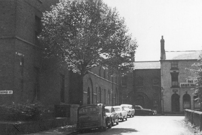
The south-eastern corner of St. John's
Square. Courtesy of David Clare. |
|
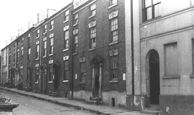
The southern side of St. John's Square.
Courtesy of David Clare. |
| Also in 1956, on 5th June, an article appeared in
the Birmingham Post about what had happened to St. James'
Church. Because of declining attendances, the church had been
closed in September 1955, and the parish had been split,
part of it being added to St. Peter's and the other part to St.
Stephen's. An accompanying photograph shows the church being demolished, but the article
points out, some bits of it were going to newer churches. St. Peter's, at Rickerscote, near Stafford was to get the stone pulpit and font, the oak screen
and the bell. St. Joseph's Church at Merry Hill, Wolverhampton, was to get the organ,
the lectern, and some of the church plate. |
|
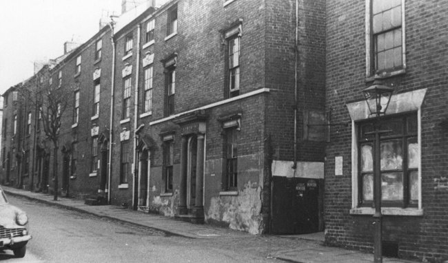
Another view of the southern side of St.
John's Square. Courtesy of David Clare. |
| But both squares were now embarking on important phases
of their lives. For one of them there was partial survival
and renewal; for the other, destruction. St. John's Square
had clearly deteriorated badly. No doubt it was going down
hill before the Second World War. Lack of maintenance during
the war would have made things worse. As soon as post
war reconstruction might have started, the area would have been
blighted by the threat of the ring road, and slum clearance. It was a fate shared by many Georgian and Victorian areas throughout the
country, and the spirit of the times was to demolish and rebuild. The south side
was flattened and replaced by the ring road. |
|
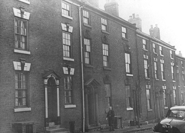
A final view of the southern side of St.
John's Square. Courtesy of David Clare. |
| Not until the mid-60s did the enthusiasm for
destruction wane. The result was that many buildings on the west
side of St. John's Square were pulled down to be replaced by modern offices. The new
office block on the north west of the square, designed by Twentyman, Percy and Partners for the Borough Council, won a
Civic Trust Commendation for its "courageous attempt to
re-establish an 18th century square." The new work has a strong
link in scale and rhythm with 18th century practice and the colour
relates well with the church and its surroundings. The Trust was not
so flattering about the other new buildings on the north side. The whole
of the south side was demolished, making the square no longer a square,
though it retains that name. The church, whose congregation had been somewhat
boosted when it joined forces with the Lithuanian Church, was saved by a massive
appeal, conducted nationally. The whole church was eventually re-cased, an
enormous undertaking, largely financed by Sir Jack Hayward. |
|
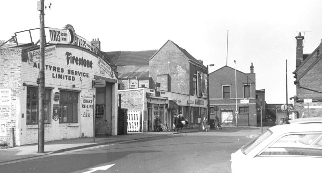
The western side of St. James's Square.
Courtesy of David Clare. |
| St. James's Square had no reprieve. People had moved out of the area, largely because of the
massive slum clearance scheme on that side of town. The square
had
fallen on hard times, and spent its last days with a few scattered
businesses, and a bus terminal. The square eventually fell to the sixth and final
stage of the ring road.
So thoroughly has it vanished, that who
now could point, with confidence, to the place where it once
stood? |
|
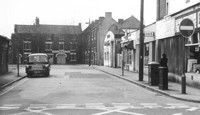
Another view of the western side of St.
James's Square, as seen from Horseley Fields.. Courtesy of David Clare. |
| Conclusions Throughout the history of the squares, the impression given is
of St. John's superiority over St. James'. St. John's was always the "better"
area. The fact that it was largely planned, and that it centred on a fine
classical church, always gave it the edge over the more industrialised St.
James'. It may
well be significant that the residents of St. John's Square appear to have
stayed living in the same house from one generation to another, while in St.
James' Square, the residents seemed to be "just passing through".
The preference for St. John's over St. James' is reflected in
the numbers of photographs in the Wolverhampton Borough
Archives. St. John's church has thirty-five photographs, and its
Square thirty-three. There are only four photos of St. James'
Square, two of these being the same picture from a slightly different
angle. |
|
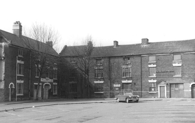
The north-eastern corner of St. James's
Square. Courtesy of David Clare. |
| Perhaps the ultimate humiliation in the history of the square, and
also the church of St. James, comes from its failure to be remembered in the current ring road
names. Surely the most obvious name for the final stage of the ring road should
have been "St. James'". But, it seems, some patriotic person, decided that as St. George's, St. Andrew's and St. Patrick's were
all included around the ring-road, St. David's should also be included. The fact
that St. George's, St. Andrew's and St. Patrick's are all names of
churches that either once stood, or are still standing, on or near the
road and that St. David's never was, seems to have eluded those
responsible. Surely, if for that reason only, the name of the final
stage of the road, should have been St. James. |
|
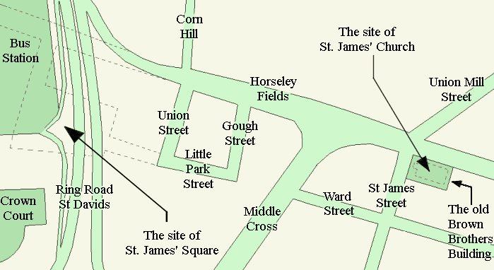
The ring road today, showing the location of
St. James' Square, and St. James' Church. |
| I would like to thank David Clare for his help in producing this
section. |
 |
Return to the
previous page |
|