| By the 17th century the population of Darlaston had
grown considerably. In 1601 Queen Elizabeth's Poor
Relief Act was implemented and recorded that the town
consisted of 600 houses, and 3,000 people. During the
17th century about £400 was paid annually to the poor of
Darlaston which shows that the welfare state is not new.
It's hard to imagine that such a large population could
have existed on agriculture, and its inevitable service
industries. By this time early industrialisation must
have started, although on a very small scale. The many
local surface deposits of coal, and the nearby iron ore
deposits must have been used in a variety of cottage
industries. The iron produced from the ore was known as
blond or blend metal, very similar to the cold shear
iron from the Cannock area. It was a good quality
product, used in nail making and for tools, such as
hammers. Some of the earliest evidence for mining in
the area can be found in records relating to
neighbouring Wednesbury. In 1315 John
Heronville, lord of the manor of Wednesbury died. John’s
widow Juliana was entitled to one third of the estate
for life (her dower) or until she remarried. The
document relating to the dower is an important record,
giving details of much of the estate. It records several
coal pits, and as such is the earliest record of coal
working in the town. Similarly it contains the earliest
record of ironstone mining in the town. |
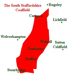
| Darlaston is situated on part of the South
Staffordshire coalfield, where the middle coal measures
are found, which were locally known as the ten yard
seam. This forms a gently folded shallow syncline that
outcrops in a wide arc from Dudley through to Darlaston,
and actually consists of 12 to 14 closely overlying
seams, giving the appearance of a single bed of coal.
This is usually less than 400 feet beneath the surface,
and in many places can be found just a few feet below
the surface. The mineral rights belonged to the Lord of
the Manor and anyone wishing to dig for coal had to
acquire a copyhold, which was a legal document obtained
via the courts. Such surviving documents provide
evidence for early mining in the area. |
 |
|
In 1698 Timothy Woodhouse was manager of the coal
mines belonging to Mrs Mary Offley, who was the Lady of
the Manor. He had a two year contract and was paid
£20.00 a year, for which he maintained the buildings,
looked after the horses, collected arrears, hired
colliers, and organised sales. In the first year he sold
3,000 sacks of coal and later went into partnership in
his own business.
Another record states that Edward Blakemore, a
nailer, had a milking cow, barley, winter corn, and
land. He was owed £30 by the Lady of the Manor, Mrs Mary
Offley for coal, and expected that his executors would
go to law to recover it. This shows that much of the
early industry was done on a part-time basis, shared
with farming.
Records do survive from 1415 which mention plots of
land lying between coalfields in Bradley. A deed of the
Perry family dated 1401 mentions two coal pits in
Bilston. One was called the Hollowaye, and the other the
Delves, both of which were situated near Windmill Field.
Camdens Brittania, published in about 1580 has this
entry:
The south part of Staffordshire hath coles digged
out of the earth, and mines of iron, but whether to
their commodity or hindrance I leave to the inhabitants
who do or shall better understand it. |
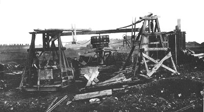 |
A typical gin pit. Large
numbers of these were in common use until the early
years of the 20th century. |
| Until the mid 18th century coal was not used for
heating in the home, it was only used for this purpose
when moss and wood became harder to obtain. Shaw, who
was writing at the close of the 18th century had this to
say about mining in the area:
There are several coal-pits sunk lately, and
probably will soon be more, as they have lately cut a
canal through the parish to Walsall. There is only one
coal mine at which they work now in this parish, in
which the coal is about 7 yards thick. The ironstone is
about three quarters of a yard thick, and is found in
the parish under the coal. The mines are very subject to
damps. The miners are subject to asthmatic complaints,
and very few of them live to be seventy years of age.
The air is sharp and dry. There is great plenty of
brick, tile and quarry clay; in some places not more
than 4 feet, and in others a great deal more. There is a
mine of clay now at work in which they have gone 13 or
14 feet deep, and it is then good. They are prevented
going deeper by water.
This is interesting, but Shaw must have been wrong in
his assertion that just one pit was at work at this
time. He also notes that the following traders were at
work in the town:
gun-lock makers, nailers,
fet makers, chape forgers, chape makers, stirrup makers,
buckle-ring forgers, and miners.
A document dated 1750, concerns a letter from
Darlaston coal mine under-manager, Joseph Lytcott to its
owner. With the aid of a map, he advises the owner, not
to sink any shafts in the vicinity of Clarke's Close,
because of the danger of meeting other workings
underground, which could cause flooding.
I think it advisable that a pitt be sunk in the
lane leading to Birmingham and that they drive a road by
the lane side along Mrs. Cookes hedge to prevent or
discourage her getting coal under the lane, for I
understand she's one that will loose nothing she can get
by any means fare or fowl. I have picked the
place in the lane as you will see between
x..............x if they sink and work in Clarke's Close
all the water in Cookes and some of Shiltons must
inevitably come upon in as you may see by the drop of
the coal, and if the road I speak on be driven to secure
Mrs. Cookes forthwith as may be done it must be while
she's working and then she will drain the water from us
- if she have any and if you approve of this I will
write to Mr. Wood to say I goe for London and call at my
coming down to see whether it be performed.
Joseph Lytcott
Clarke's Close was an area of about six acres and
contained twenty three pits, of which seven were
at work. The shafts were closely spaced as can be seen
from the sketch, at Kitchen Croft they where not more
than fifty yards apart. This is a clue to the type of
pits being worked, namely bell pits, as the limit for
underground working would have been within about a
twenty five yard radius from the shaft. The leap
mentioned in the sketch is probably a fault, and a sough
was a drain to remove water from the mines. |
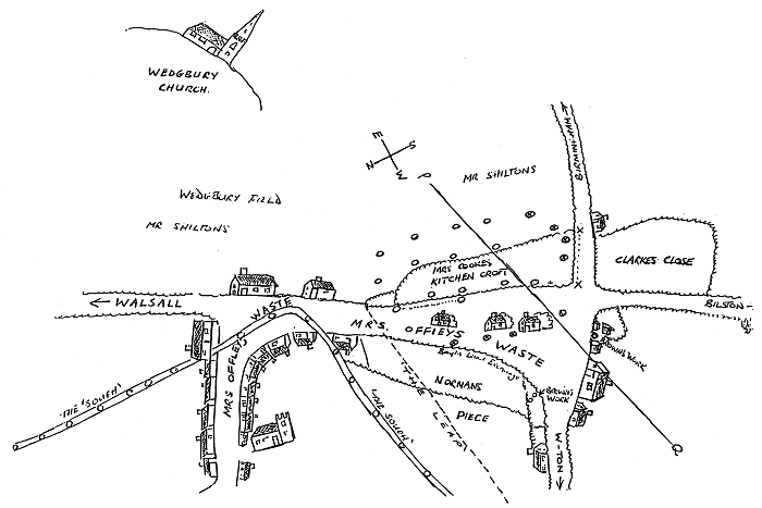
The road to Birmingham is
Dangerfield Lane, the road to Bilston is Moxley Road,
the road to Wolverhampton is Wolverhampton Street, and
the church at the bottom left hand corner is Saint
Lawrence's. |
Much of the area around Pinfold Street,
particularly on the southern side was heavily
mined, as can be seen from the drawing above. In
the late 1770s one of the most successful coal
and iron producing families in the Black Country
moved there. John Bagnall, his wife Margaret and
their children moved to Pinfold Street from
Broseley. Behind their house was a piece of land
where John opened several mines. He died in 1800,
and mentioned in his will that he extracted coal in
his garden. John and Margaret's descendants founded
and ran coal mines and iron works in Wednesbury and
West Bromwich, and created a business that became one
of the area’s largest producers of coal and iron
in the first half of the 19th century.
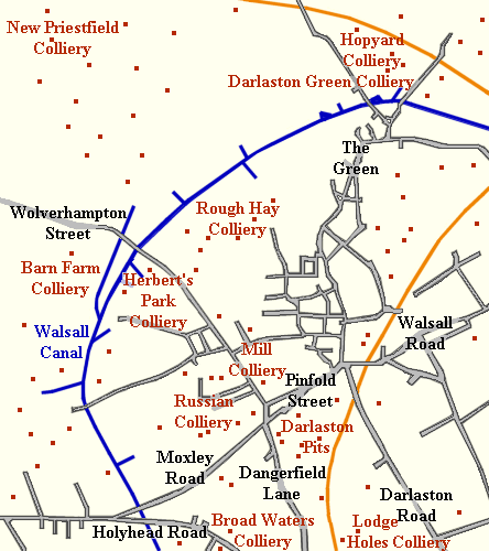
Herbert's Park Colliery, Ironworks, and Furnaces
Herbert's Park Colliery occupied the site of the old
George Rose Park, much of which is now part of Grace
Academy. The colliery covered just over 18 acres,
and was run by William Marshall, and Henry Rogers.
The minerals mined included new mine coal, fireclay,
new mine ironstone, and rough hill ironstone. In 1842
the business went into liquidation and was sold at
auction. |
|
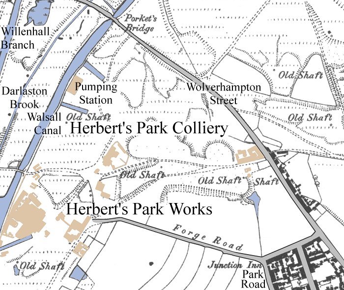
The location of Herbert's Park
Colliery, ironworks and furnaces. |
| The bankruptcy notice in the
London Gazette:
Herbert’s Park
Colliery
To be sold at
auction by John Fellows on Thursday the
27th day of October 1842 at the Waterloo
Rooms in Waterloo Street, Birmingham, in
the county of Warwick, at twelve o’clock
at noon precisely, pursuant to an Order
of the Court of Review in Bankruptcy,
and by the direction of the assignees of
William Marshall and Henry Rodgers,
bankrupts, free from auction duty, and
subject to conditions to be then and
there produced.
All that undivided
moiety, or equal half part, or other the
part share, estate and interest of the
said bankrupt, William Marshall, of and
in those sic closes, pieces or parcels
of land, known by the name Herbert’s
Park, with the mines and minerals now
remaining un-gotten in and under the
same, situate in the Parish of
Darlaston, in the county of Stafford,
containing by measurement, 18 acres, 16
perches, or thereabouts, and in part
bounded by the Birmingham and Walsall
Canal.
The new mine coal,
the fireclay, the new mine
ironstone, and the rough hill ironstone
have been proved. Several pits or shafts
are sunk in the land, and a winding and
pumping engine for getting coal, and two
winding engines for getting ironstone,
are now standing thereon.
For further
particulars apply to Messrs. Mallaby and
Townsend, Solicitors, Liverpool; Messrs.
Stubbs and Rollings, Solicitors; or to
the Auctioneer, of Birmingham.
|
|
| In the list of owners and occupiers that
accompanied the 1843 tithe map of Darlaston,
the colliery is listed as belonging to
Messrs Taylor & Company, but David Jones
soon purchased the colliery and
built Herbert's Park Ironworks. Within a few
years there were fifteen puddling furnaces,
two blast furnaces, and a narrow gauge
tramway to the coal mines. On 12th June,
1851 there was an explosion at the works. It
is mentioned in 'A History of Mining in the
Black Country' by T. E. Lones, 1898.
From
1875 to 1880 Herbert's Park Colliery is
listed as being owned by David Jones & Sons,
then in 1885 by Thomas & I. Dowen, and
from
1915 to 1918 by Samuel Weaver. It seems that
the colliery had ceased to be used by the
late 1880s. It is marked as disused on the 1889
Ordnance Survey map. |
|
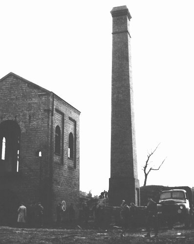
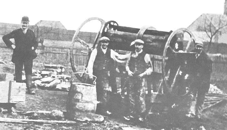
The demolition of the
pumping station chimney in the 1960s. |
On the left is the old pumping engine that
pumped water out of the colliery, into the
canal. It stood beside the canal until
demolition in the 1960s. I remember it as a
child, when it contained a beam engine. |
Some of the larger pits in 1869 were as follows:
| Colliery |
Owner |
| Albert Colliery |
David
Rose |
| Bescot Colliery |
Darlaston Steel and Iron Company |
| Darlaston Green
Colliery 1 |
James
Sanders |
| Darlaston Green
Colliery 2 |
George
Oates |
| Greens Farm
Colliery |
Greens
Farm Colliery Company |
| Herberts Park
Colliery |
David
Jones |
| James Bridge
Colliery |
J.
Bagnall and Sons |
| North-western
Colliery |
J.
Simpson |
| Rough Hay Colliery |
Addenbrooke and Co |
| Victoria Colliery |
John
Dutson |
Darlaston pits in 1880 included:
| Colliery |
Owner |
| Bull Piece |
G.
Spruce. |
| Broadwaters |
David Rose |
| Russian
Colliery |
David Rose |
| Darlaston
Green |
Price and Company |
| Darlaston
Green |
James Saunders |
| Heathfield |
J.
and J. Cotterill |
| James Bridge |
J.
Bagnall and Sons |
| King's. Hill |
Bayley and Hunt |
| King's. Hill |
Joseph Springthorpe |
| Rough Hay |
Simpson and Company |
| Rough Hay |
Butler and Company |
| Rough Hay |
Bargwin and Company |
| Rough Hay |
Joseph Baugh |
| Rough Hay |
Williams and Company |
| Moxley |
Evans and Collis |
The larger pits in 1896 were:
| Colliery |
Owner |
| Moorcroft
Colliery 1, Moxley |
Moorcroft Colliery Company |
| Moorcroft
Colliery 2, Moxley |
G. W. Bray |
| Moxley
Colliery |
Jacob Chilton
|
| Rough Hay
Colliery |
S.
Yates |
| Woods Bank
Colliery |
Hewitt and Company |
| Woods Bank
Colliery |
James Cotton
|
| Heathfield
Colliery |
George Lester |
|
| Another colliery, Mill Colliery, was in Mill Street.
It was a deep pit into which sand was pumped for several
weeks in the mid 1950s to prepare the ground for the
building of the row of shops and the flats in
Catherine's Cross. It was named after Darlaston windmill
in Dorsett Road.
The Bell pit method of mining involved digging
outwards from a central shaft in many directions, until
the roof was in danger of collapsing. The pit was then
abandoned and another dug. Sometimes a pair of shafts
would be dug about 50 yards apart and joined by an
underground passage in order to allow circulation of
air. The coal would then be removed from the sides of
the connecting passage. This very wasteful technique
could be employed because coal was so plentiful and
easily obtainable. Later when larger pits were dug,
columns of coal were used to support the roof instead of
wooden props, and so many tons of coal must have been
lost in this way. Most of the mine companies were very
small, owning just one or two pits.
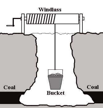 |
A typical bell
pit. The shaft is dug down to the layer of
coal and the spoil is removed in a bucket
that is wound up and down the shaft by a
windlass. When the coal is reached the sides of the
shaft at the bottom are widened as the coal
is removed. This process continues until the
shaft is in danger of collapsing. The pit is
then abandoned and a new one dug nearby. |
The shafts would eventually collapse or be filled-in
with spoil from nearby workings. Eventually little
hollows would form above the shafts. These hollows could
be found on much of the open land in the Darlaston and
Bentley area, until the building projects of the 1960s
and 1970s removed them forever. |
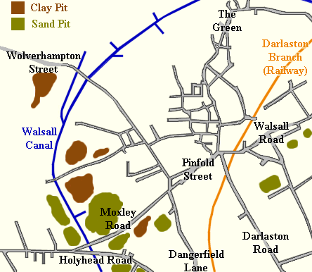
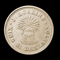
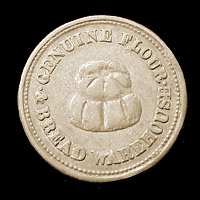
| The clay beds gave rise to the
local brick and pot industry. These deep excavations and the
many mining spoil heaps have sculpted the Darlaston
landscape, which is now very different to how it
used to be. Popular sporting activities in the 17th and 18th
centuries included dog fighting, cock fighting and bull
baiting. In the 18th century coins were in short supply
and several trade tokens were made for general
circulation. The one below was produced by miller and
bread maker J. Huskins of King Street. |
Darlaston had at least one windmill. Morden's
map of 1695 shows a windmill on the brow of the hill
near the top of Dorsett Road.
| |
|
Read about
Darlaston Windmill |
 |
| |
|
|
|
|
|
|
Return to Early
Historical References |
Return to
Contents |
Proceed to Nail
& Clock Making |
|